Cowtown today is surrounded by several big lakes, but it has lost several small lakes.
Katy Lake
Katy Lake is perhaps the best remembered of the lost lakes (in fact, Katy Lake has its own post here).
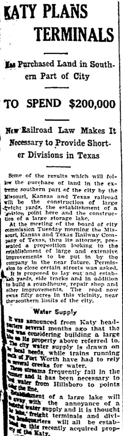 As this Fort Worth Telegram news story from July 30, 1907 indicates, on that date the Katy (Missouri-Kansas-Texas) railroad announced that it would impound a “large storage lake” in the south part of town to supply water for its steam engines.
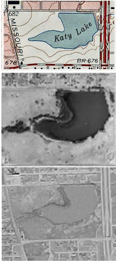
Photos show the Katy Lake dam along Bolt Street and Interstate 35W. A creek flowing in from the west fed the lake. Katy Lake was drained in 1959 for the construction of Seminary South mall, which opened in 1962. The Katy track still skirts the mall on the western edge.
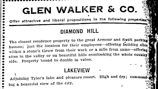
Other lost lakes of Cowtown include Tyler’s Lake and Elliot Lake on Riverside Drive, Tandy Lake on East Lancaster Avenue, Hust Lake on the East Side, Silver Lake on the South Side, Lake Togo on the North Side, and Lake Erie in Handley.
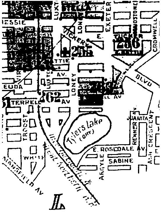
Tyler’s Lake
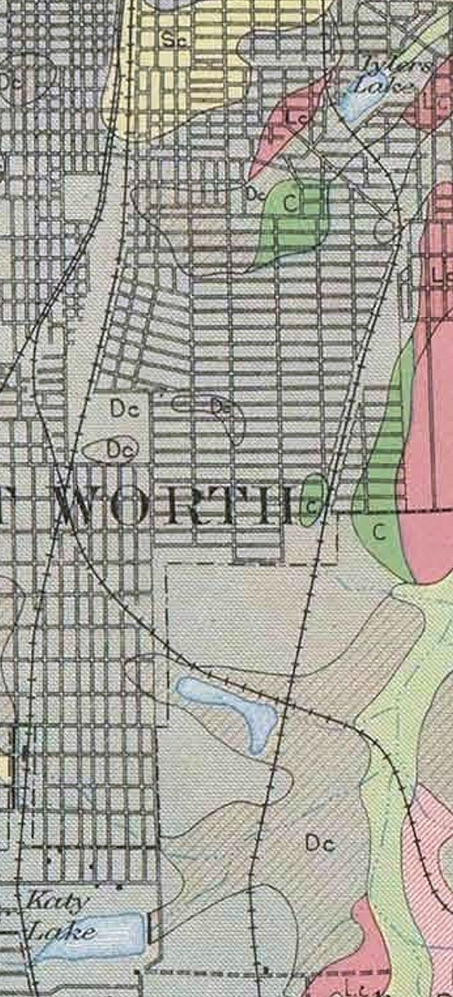
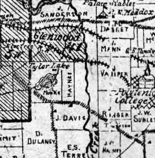 Tyler’s Lake is shown on this 1895 map. The lake, named for developer James L. Tyler, was located on today’s Riverside Drive south of Vickery Boulevard in Glenwood Park. The map shows Polytechnic College to the east. Tyler’s Lake was fed by a creek that still flows into Sycamore Creek in Sycamore golf course. (Map from Pete Charlton’s “1000+ Lost Antique Maps of Texas & the Southwest on DVD-ROM.”)
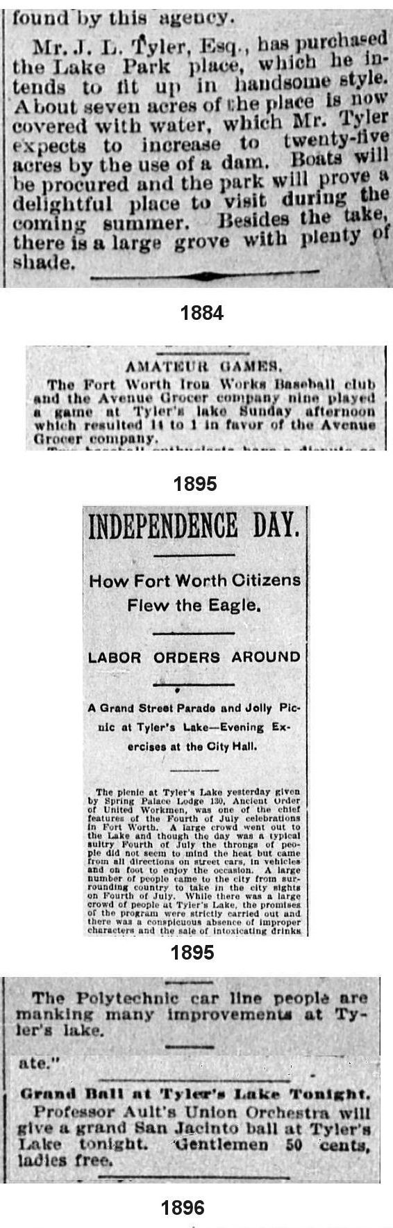 Tyler’s Lake was a popular recreational area into the early twentieth century when Glenwood was a thriving community not yet part of Fort Worth.
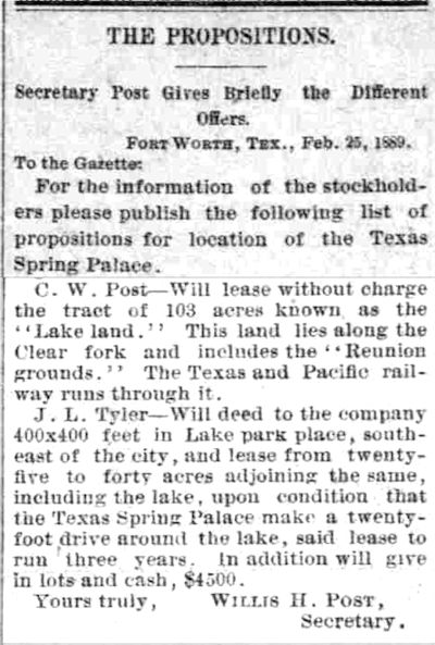 In February 1889 James L. Tyler even proposed that Fort Worth’s Spring Palace exhibition be held at his lake. People in several parts of town, including future cereal czar C. W. Post, made similar proposals for other parts of town.
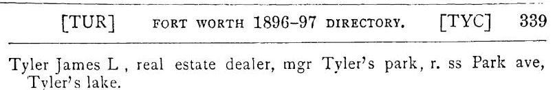 In 1897 James L. Tyler lived on Park Avenue, which was then a street adjacent to his park.
 This USDA soil map detail shows Tyler’s Lake, Echo Lake (just east of I-35W and south of Berry Street; unlabeled at the railroad intersection on this map), and Katy Lake. (Echo Lake, built by the International & Great Northern railroad, survives in the city’s Echo Lake Park.) (Map from Pete Charlton’s “1000+ Lost Antique Maps of Texas & the Southwest on DVD-ROM.”)
 In 1903 Lakeview addition was developed south of Tyler’s Lake. The Lakeview streetcar line opened in 1909.
 But by 1927 the residents of Lakeview had no lake to view: A Sanborn map labeled Tyler’s Lake “dry.”
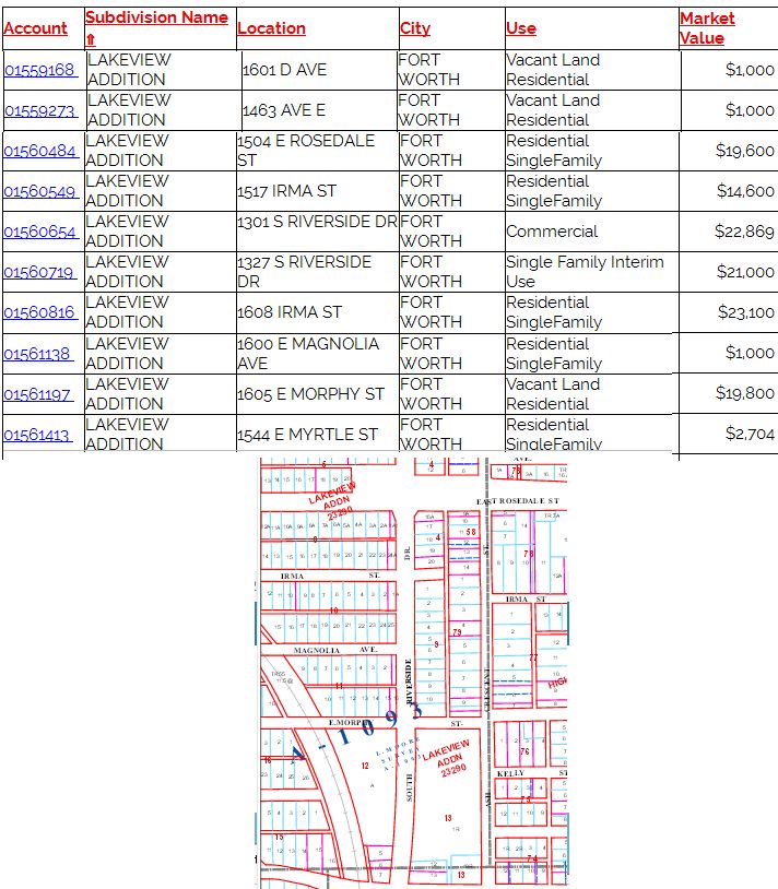 But the addition named for its view of Tyler’s Lake lives on in Tarrant Appraisal District records.
 And in today’s Glenwood Park the creek that fed Tyler’s Lake still flows.
Elliot Lake
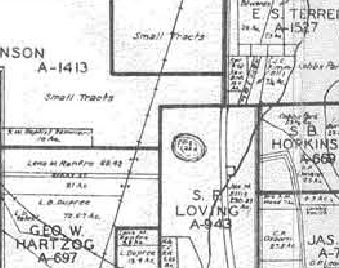 A 1941 map shows a round “fish pond” just northeast of the eastern end of Berry Street and just west of South Riverside Drive. That was Elliot Lake. (Map from Pete Charlton’s “1000+ Lost Antique Maps of Texas & the Southwest on DVD-ROM.”)
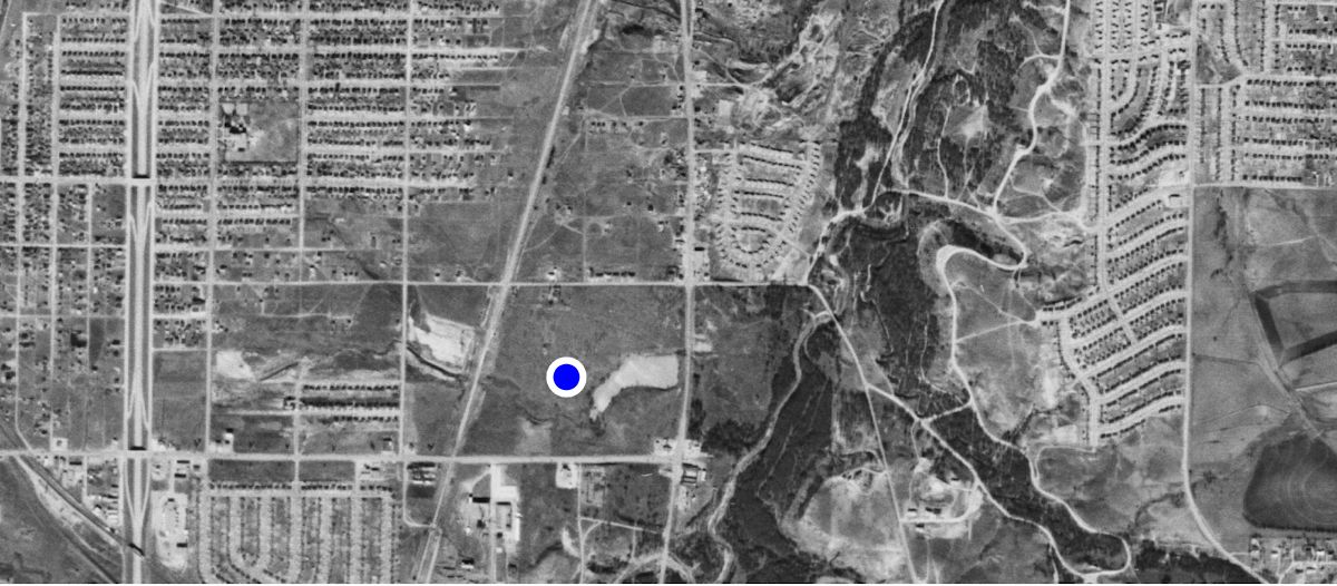 By 1952 this aerial photo shows the fish pond to be larger and to have a dam parallel to Riverside Drive. By 1952 Berry Street had been extended east to Riverside Drive. The major north-south highway along the left is the new Interstate 35W.
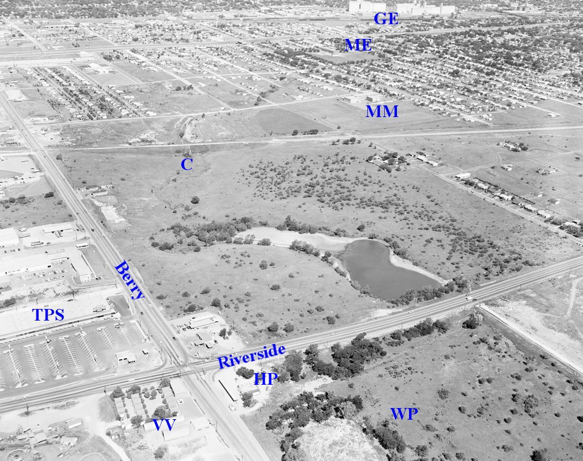 This 1959 aerial photo shows a diminished Elliot Lake. The creek that fed the lake is channeled through a culvert (C) under the I&GN railroad track. In the lower right, overflow from the lake is carried by a concrete channel east to Sycamore Creek. That channel is now underground.
 Elliot Lake was in the northwest quadrant of what was once a busy intersection. Elsewhere in the aerial photo, Towne Plaza South shopping center (TPS on the photo) opened in 1959 at the intersection of Berry Street and Riverside Drive with these businesses: Skillern’s drugstore, TG&Y store no. 2, White’s auto store no. 7, A&P grocery, Gulf gas station, jeweler, coffee shop, liquor store, barber, dry cleaner.
The aerial photo was taken the year Montgomery Ward announced plans to build Ward Plaza (WP) in the northeast quadrant of the intersection. The land on which Towne Plaza South and Ward Plaza were built had been part of the Ellis family empire.
In the lower left of the aerial photo can be seen part of Southside Playgrounds and Miniature Golf. Next to the playgrounds is Valley View Motor Court (VV). A motel is still there but no longer offers cabins.
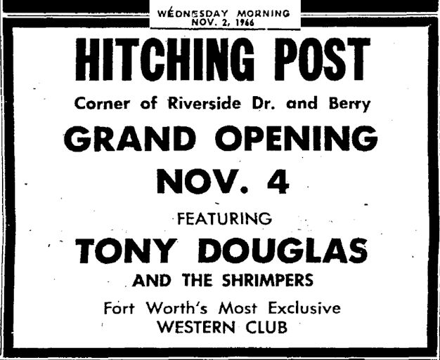 The building labeled HP would become the Hitching Post night club in 1966.
In the distance are Morningside Elementary School (ME), Morningside Middle School (MM), and the Kimbell and Producers Grain elevators (GE) on South Main Street. (Photo from University of Texas at Arlington Library. Thanks to Ghost Writer in Disguise for the tip.)
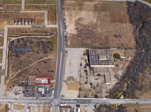 A recent Google aerial photo labels the body of water “Elliot Lake,” although the lake was dry by 1970. To the right is abandoned Ward Plaza.
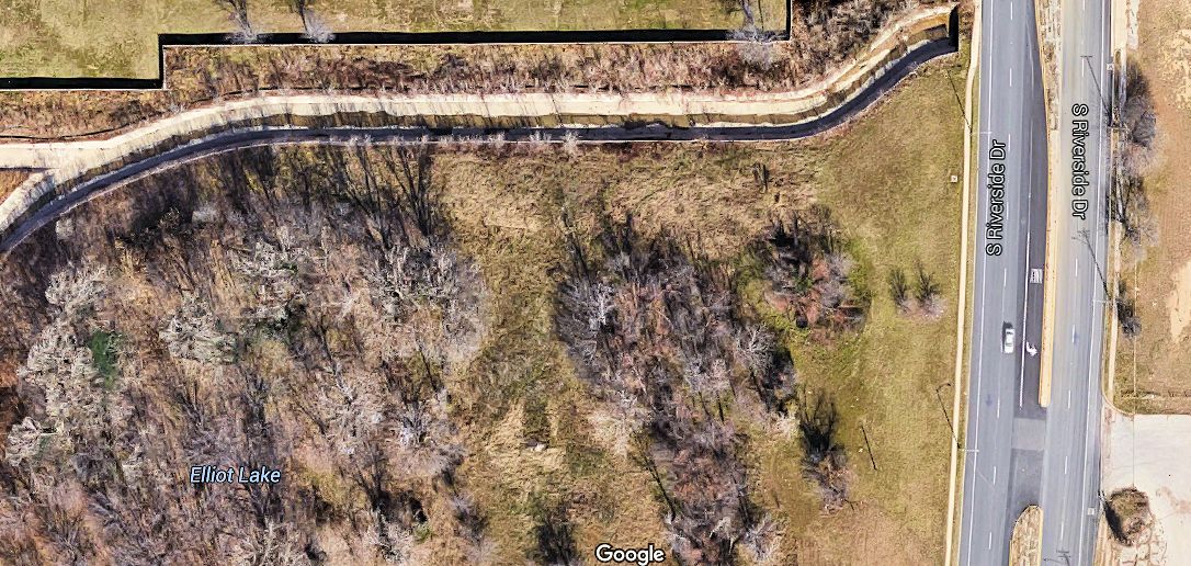 The creek that fed Elliot Lake has been channeled from Nara Vista Trail around the old lake bed and into a tunnel that passes under Riverside Drive and eastward to Sycamore Creek.
Tandy Lake
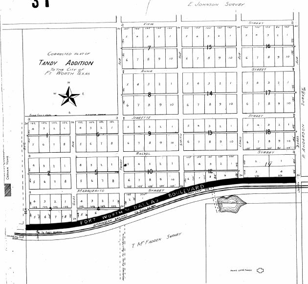 This plat provided by Caleb Tandy shows Tandy Lake just south of “Fort Worth-Dallas Boulevard” (Lancaster Avenue) on the East Side near the Tandy Lake stop on the interurban. East Side pioneer Roger Tandy in the nineteenth century dammed a creek on his sprawling ranch to form a lake between today’s Ayers and Collard streets. Tandy Lake, like Tyler’s Lake, was a popular recreational area. According to the Star-Telegram the lake was drained in 1918 in response to the flu pandemic. The home of Poly civic leader George Tandy, son of Roger, is labeled in the lower right of the map. Some of the streets north of Lancaster were named for Tandy family members. During the first half of the twentieth century the neighborhood had a Tandy Lake Grocery, Tandy Lake Service Station, Tandy Lake Drug Store, and Tandy Lake Garage. George Tandy Elementary School north of the lake originally was called “Tandy Lake School.”
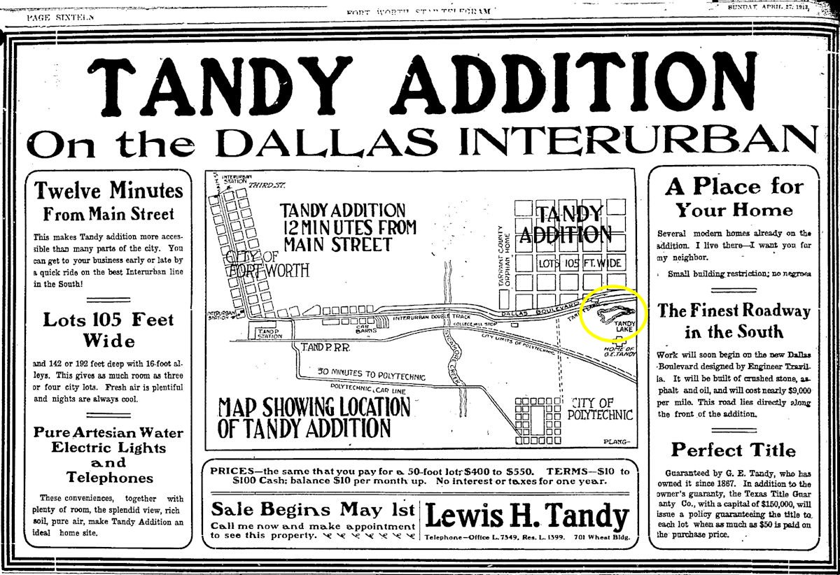 The lake also appears on this 1913 ad for the Tandy addition, developed just north of the lake by Lewis Tandy.
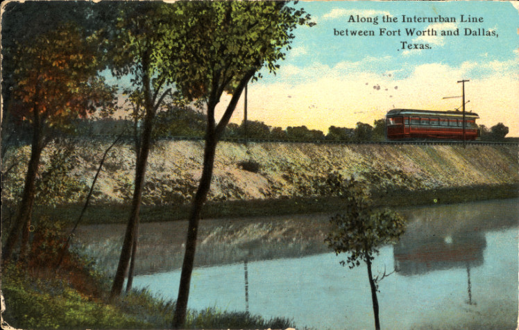 This postcard may depict an interurban car passing Tandy Lake.
Hust Lake
 Farmer John A. Hust, elected Tarrant County’s first tax assessor in 1850, lived nine miles east of the fort and just north of the Trinity River near today’s intersection of Randol Mill Road and Precinct Line Road.
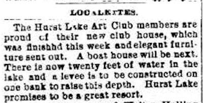
 In 1887 a low-lying area of the river bottom on Hust property was impounded to form Hust Lake. Hust Lake Art Club was formed, a clubhouse and boathouse built, an artesian well dug. Hust Lake was often mislabeled “Hurst Lake” because of the proximity of the lake to the town of Hurst and to the homestead of town namesake William Letchworth Hurst. In 1856 Archibald Franklin Leonard had dammed the Trinity River near Hust Lake and built a grist mill, which would eventually be owned by Robert Randol. The community of Randol formed at the mill. Clip is from the Fort Worth Gazette.
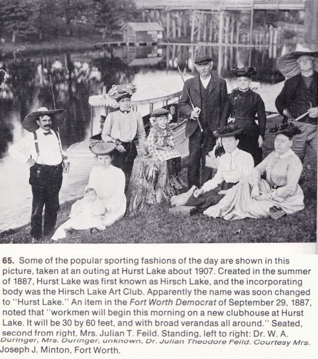 In his How Fort Worth Became the Texasmost City Leonard Sanders proposed another theory for the name of the lake. Among the people identified in this photo are Dr. and Mrs. W. A. Duringer and Dr. and Mrs. Julian Theodore Feild. Julian Theodore was a son of pioneer Julian Feild. Note the wooden bridge in the background. Precinct Line Road may have passed over the lake.
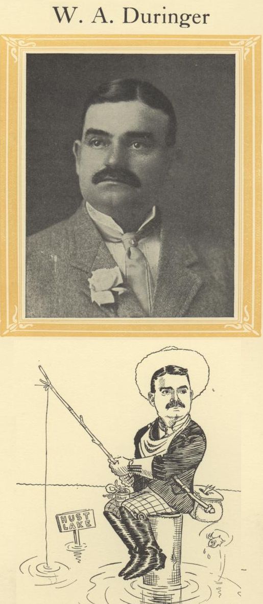 Dr. Duringer was president of Hust Lake Art Club.
 In this clip of May 6, 1909 the Star-Telegram managed to call the lake “Hust” and “Hurst.” By whatever name, well into the twentieth century the lake was a popular recreational area.
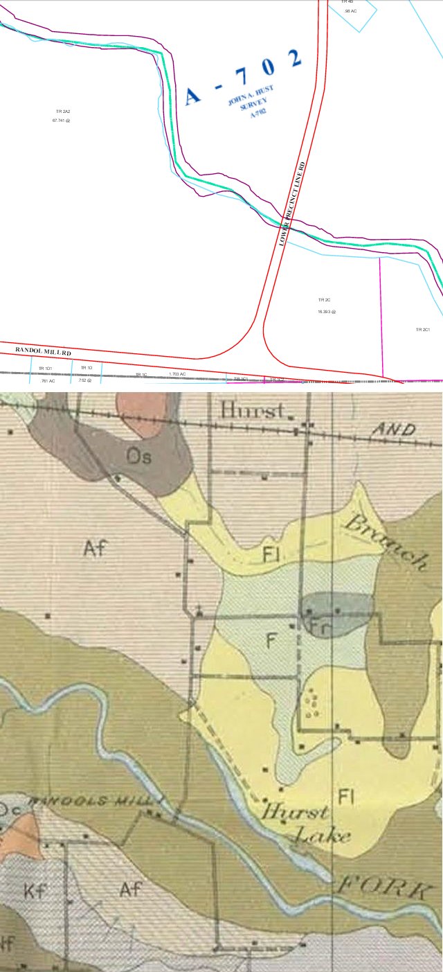
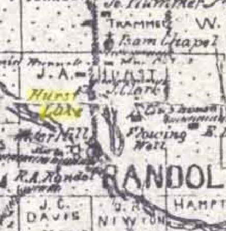
A Tarrant Appraisal District map (top) shows the land labeled “John A. Hust survey.” A 1920 USDA soil map shows Hust Lake relative to Randol Mill and the river. (USDA map detail from Pete Charlton’s “1000+ Lost Antique Maps of Texas & the Southwest on DVD-ROM.”)
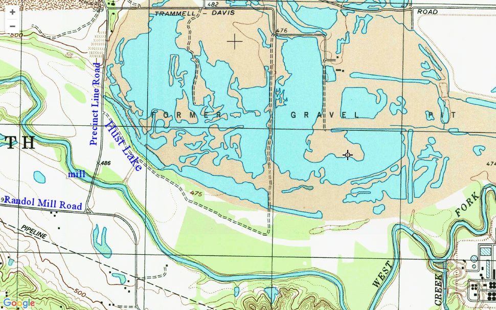 Today Hust Lake is just a low-lying area in the river bottom that, like the adjacent gravel quarry, holds water.
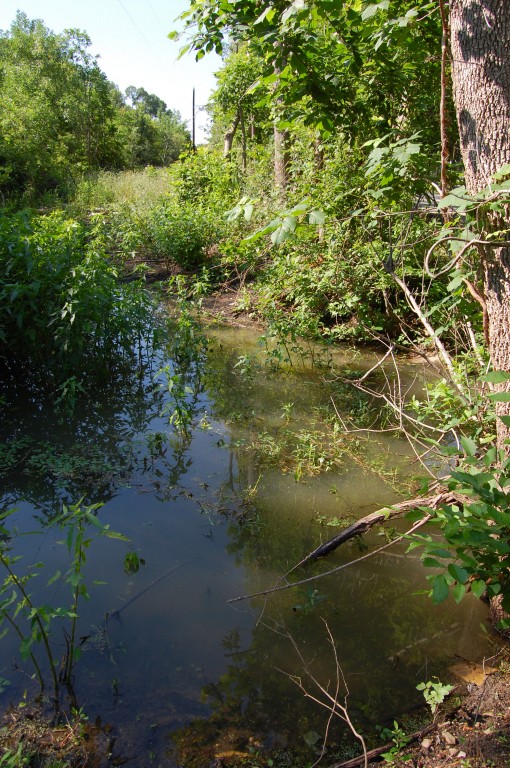 The remains of Hust Lake from Precinct Line Road.
Silver Lake
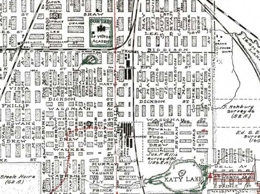
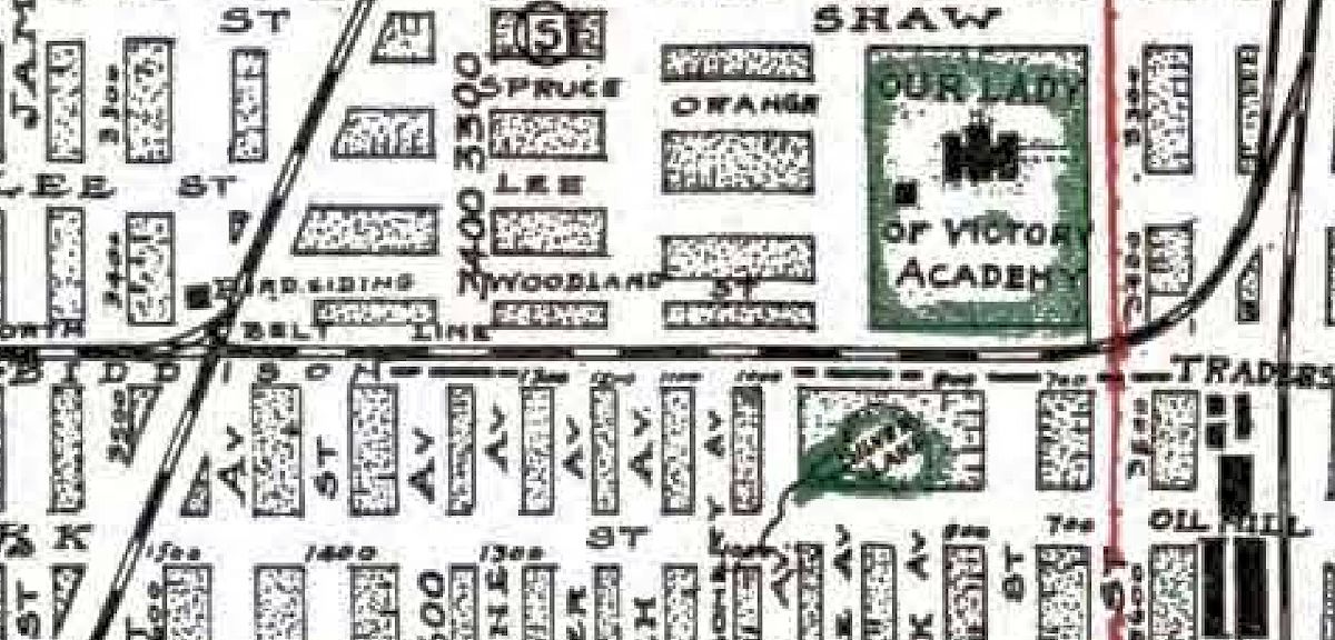 Now get out your magnifying glass ’cause we’re gonna get small. One mile northwest of Katy Lake, just across Biddison Street and the belt line railroad south of Our Lady of Victory Academy, was a smaller lake. Silver Lake was fed by a modest creek flowing northeast. (Map from Pete Charlton’s “1000+ Lost Antique Maps of Texas & the Southwest on DVD-ROM.”)
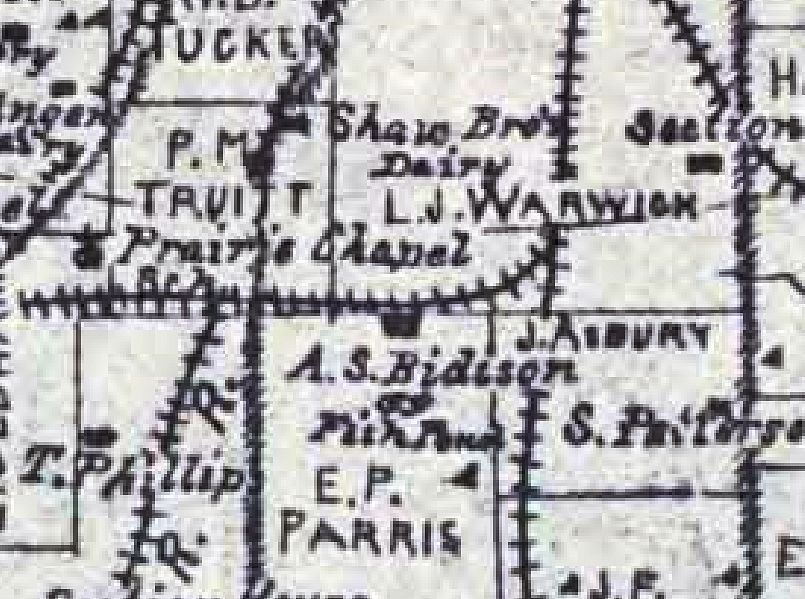 This 1895 map shows a “fish pond” on the Amon S. Biddison farm south of the belt railroad and Shaw brothers’ dairy land, which would later be occupied by OLV. In 1878 Biddison and wife Laura had settled on that land from Ohio. Reverend Biddison was a minister of the Methodist Protestant Church, a breakaway from the Methodist Episcopal Church. (Map from Pete Charlton’s “1000+ Lost Antique Maps of Texas & the Southwest on DVD-ROM.”)
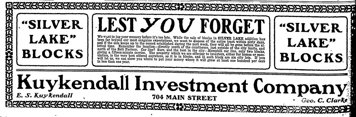 The developers of Silver Lake were E. S. Kuykendall and Fort Worth educator and South Side developer George C. Clarke.
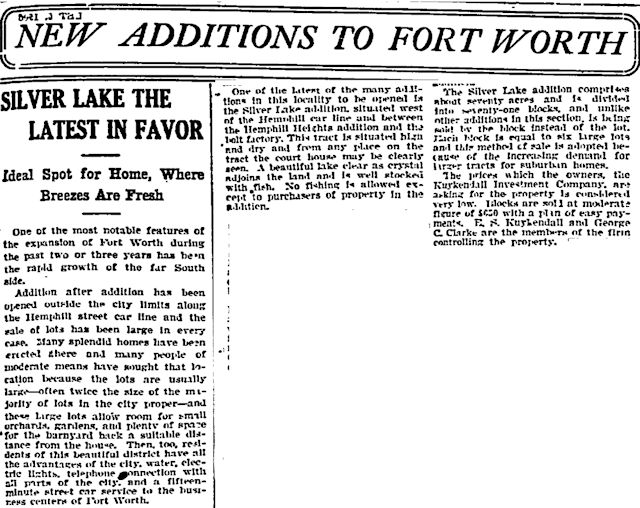 In 1906 the Biddison fish pond would be given a fancy name, and as “Silver Lake” the fish pond would be the centerpiece of the new Silver Lake addition. The addition was outside the city limits in 1906, but, the developers boasted, Silver Lake addition was “the only suburban property on the south side with graded streets.” Never mind pavement in 1906. Many streets were not even graded. Even South Hemphill Street was still unpaved in 1906. Citing the desire of 1906 homebuyers for larger lots, Silver Lake developers offered lots big enough for a “barnyard back a suitable distance from the house.” The addition was located near the “bolt factory” and offered city water, telephone and electric service, and fifteen-minute service to downtown on the Hemphill Street streetcar line. Fare: five cents. Each Silver Lake lot had a view of the courthouse. “A beautiful lake clear as crystal adjoins the land and is well stocked with fish.” Only Silver Lake residents were allowed to fish in Silver Lake.
 That bolt factory (officially “Fort Worth Iron and Steel Company”) was eight blocks southeast of Silver Lake at the intersection of Hemphill and . . . wait for it . . . Bolt streets. And see Waggoman and Fogg streets north of Bolt Street? Named for alderman and businessman Ben L. Waggoman and Ohioan W. K. Fogg, officials of the bolt factory. The factory opened in 1905. In October of that year ubiquitous photographer Charles Swartz was taking photos at the new factory when he was hit and killed by a locomotive of the . . . wait for it . . . Katy railroad.
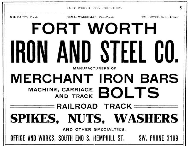 As this ad in the 1908 city directory shows, the bolt factory made much more than bolts: from washers to railroad track.
Silver Lake addition was just one of the South Side additions developed, at least in part, in response to the opening of the bolt factory as housing was needed for factory workers. The Shaw brothers, who had owned the dairy land where OLV was built, developed, with George C. Clarke, Shaw Heights and Shaw Clarke additions. South Hemphill Heights and Ryan-Pruitt additions opened. Worth Heights and South Fort Worth additions opened adjacent to the bolt factory. Despite all this development, Biddison Street would remain the southern city limit into the 1920s. (Map from Pete Charlton’s “1000+ Lost Antique Maps of Texas & the Southwest on DVD-ROM.”)
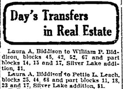 Among people selling lots in the seventy-acre Silver Lake addition was Laura Biddison, since 1900 the widow of Reverend Biddison. William P. Biddison, their son, lived next door to her. Pettie L. Leach was Laura’s daughter. Because Silver Lake developers sold the land by blocks of six lots each, not by individual lots, people may have bought blocks and subdivided them for resale.
And it appears that Elizabeth Willing Ryan was not the only woman on the South Side with her own intersection: Silver Lake addition included the intersection of Laura and Biddison streets. Two blocks west was Leach Avenue, named for Laura’s son-in-law Alonzo R. Leach.
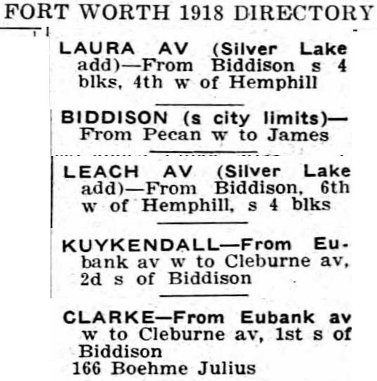 In fact, everyone got in on the name game. The 1918 city directory shows that Silver Lake had Laura, Biddison, Leach, Clarke, and Kuykendall streets.
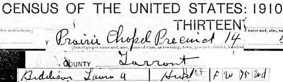 Seventy-five-year-old Laura Biddison was listed in the 1910 census as living on the Cleburne Road (McCart Avenue today) in Prairie Chapel (see 1895 map above). She apparently sold the fish pond and at least some of her farmland to the Silver Lake developers.
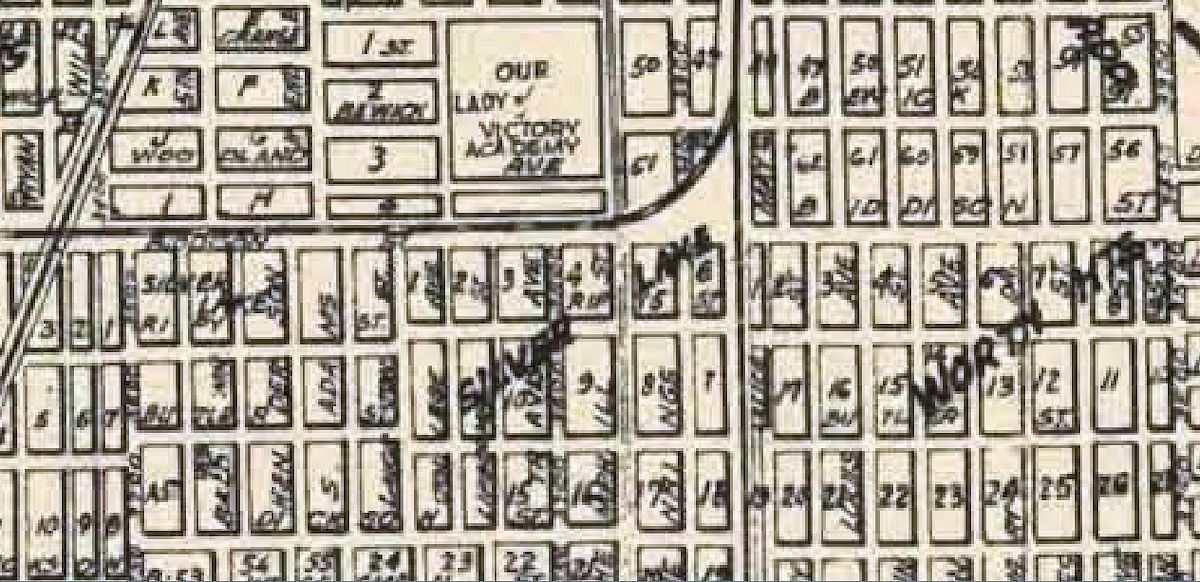 The lake was gone by 1929. (Map from Pete Charlton’s “1000+ Lost Antique Maps of Texas & the Southwest on DVD-ROM.”)
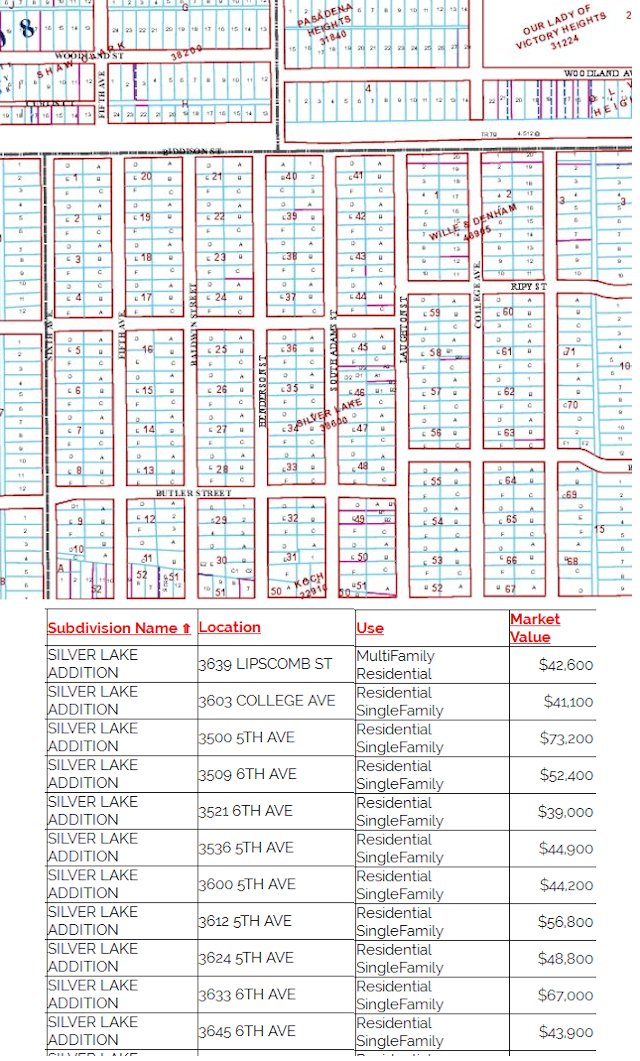 But the little fish pond that became first a lake and then a lost lake is immortalized, if only in name, on tax records. Tarrant Appraisal District lists 401 homes in Silver Lake addition.
Lake Togo
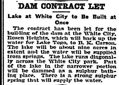
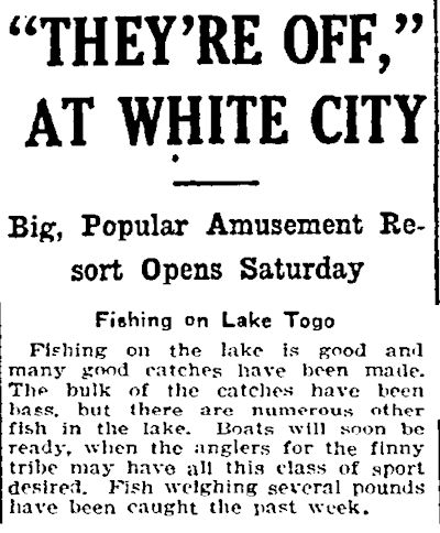
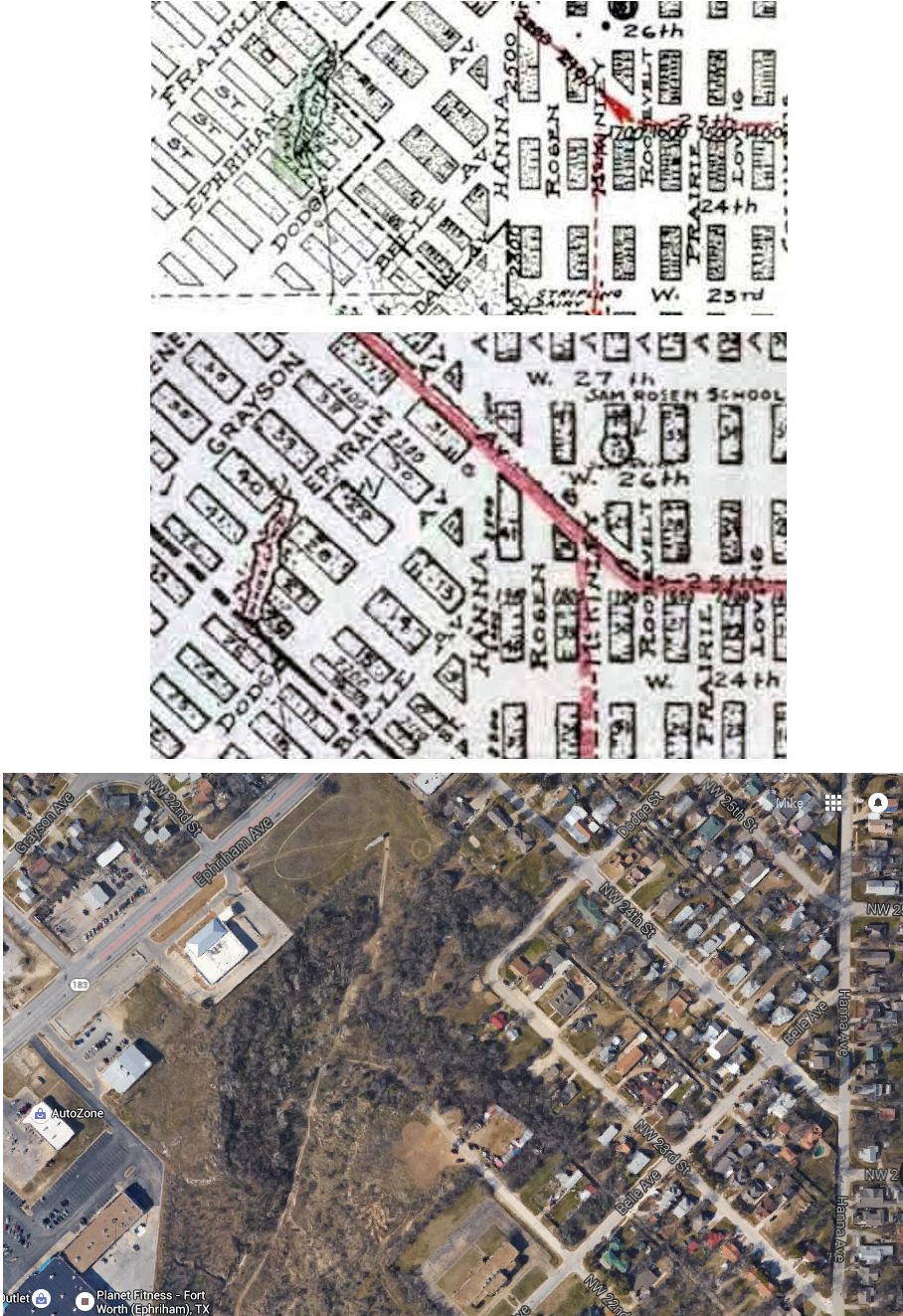 Sure, Africa has a Lake Togo in . . . wait for it . . . Togo. But a Lake Togo in Cowtown? Our Lake Togo was the centerpiece of Sam Rosen’s White City trolley park on the North Side. The park, like Silver Lake addition, opened in 1906. Rosen’s North Side streetcar line carried passengers to his park. Maps from 1919 and 1925 show Lake Togo at the intersection of Ephriham Avenue and Northwest 24th Street. The contemporary aerial photo shows that location today: Lake Togo was to the right of the AutoZone store in the heavily wooded area of low elevation fed by a creek flowing northeast. (Maps from Pete Charlton’s “1000+ Lost Antique Maps of Texas & the Southwest on DVD-ROM.”)
 White City closed about 1912. By the 1930s Lake Togo did not appear on maps.
Lake Erie
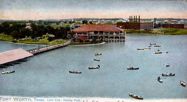 Like Lake Togo, Lake Erie was the centerpiece of a trolley park. Northern Texas Traction Company built its Lake Erie trolley park at NTTC’s interurban power plant in Handley (at the site of today’s power plant).
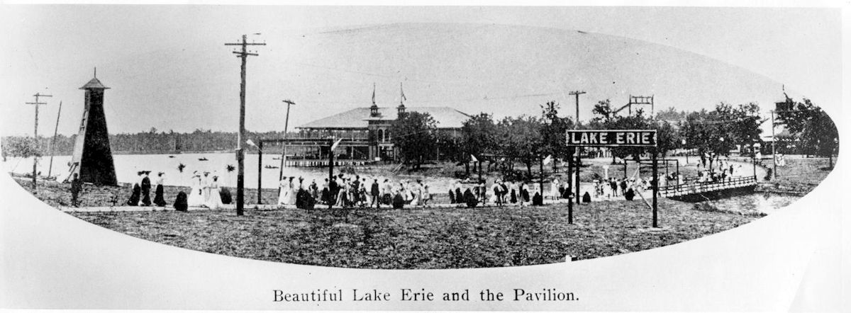 Lake Erie park opened soon after the interurban began service in 1902. The Fort Worth-Dallas interurban closed in 1934. (Photo from Arlington Historical Society’s Fielder House Museum.)
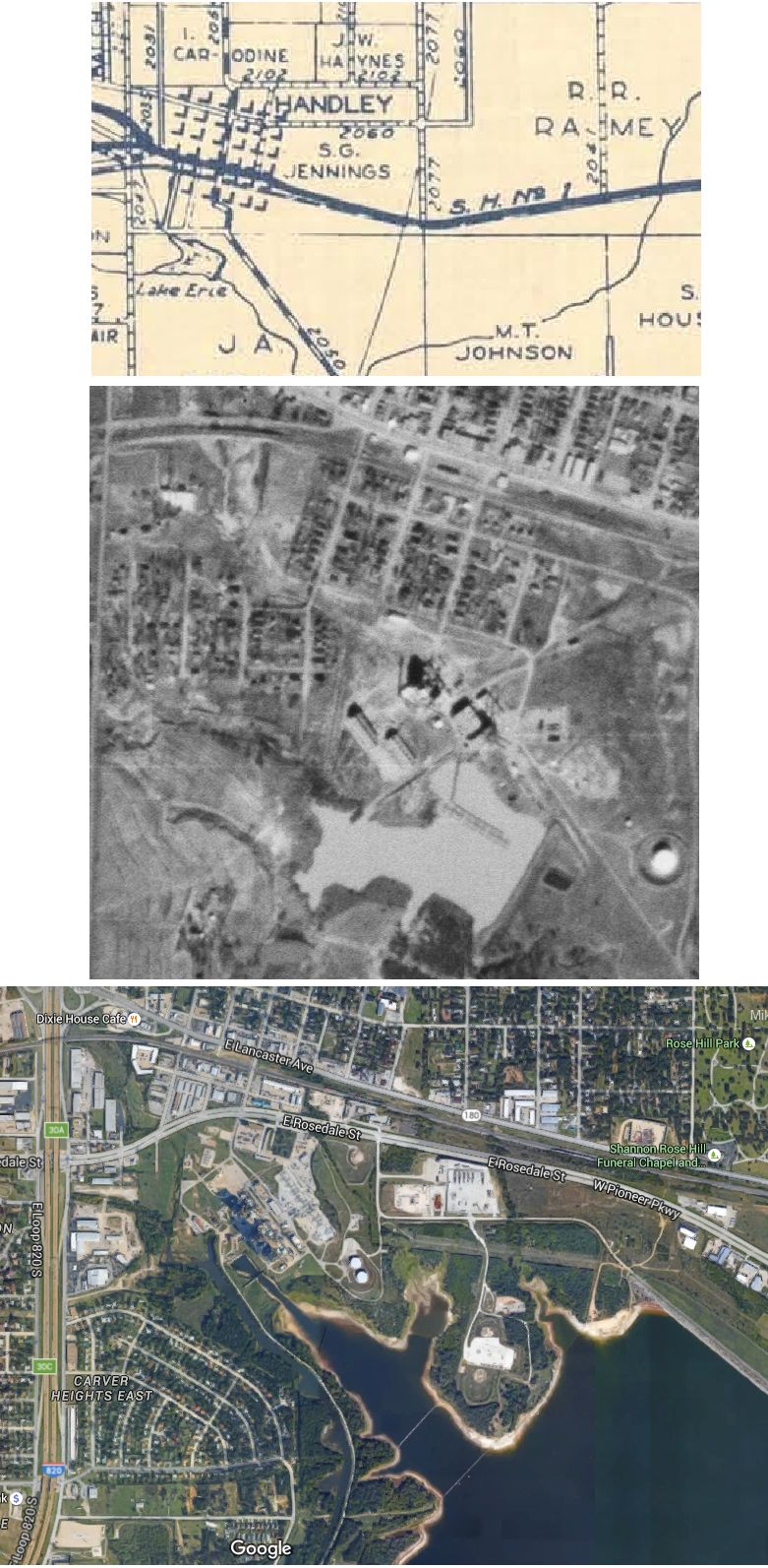 Today only a sliver of Lake Erie survives as the northwestern tip of Lake Arlington, impounded in 1957.
Of Fort Worth’s three trolley park lakes, only Lake Como survives.


…FYI, you led me down another rabbit hole and I thank you…
… Driving east on Elliott Reeder rd. from Haltom rd. I rediscovered an area called Garden of Eden historic district and the valley chapel, which of course led me to the Birdville colored school
(this part was online) a couple more random wikipedia pages…
… All this because I was searching for the lost Trinity river…
… History is like a box of chocolates, you never kNoW wHaT you will find…
Into the 1940s Garden of Eden still appeared on city maps. Now all I find are Eden Road and Eden Avenue. A similar history to Mosier Valley.
It is indeed hard to get history to walk a straight line.
Just to confirm, any one know if the “resort” at lake Como was on the South West side of the lake right?
Joe, this post has a map that shows Lake Como structures on two sides of the lake. The pavilion was on the southwest, but I assume that there were other attractions near the streetcar loop on the other side of the lake.
A 1959 aerial of half-full Elliot Lake: https://library.uta.edu/digitalgallery/files/original/a9acc3605356f1ae9662c1e00ee210ee.jpg
Thanks once again, Ghost Writer in Disguise. A great snapshot in time of East Side history. I have added that photo with some labels.
Do you know who owned the property where Katy Lake was located and what year was it was sold to build Seminary South?
Thank You
Helen, the last owner I could find was W. G. McCommas. In 1958 when the Star-Telegram announced that the mall would be built, it mentioned only who bought the lake and who negotiated the sale, not who owned the lake.
Love all the old stories about Fort Worth and the esp the Southside where I grew up at. Is there a way I could get more info? It would truly be an honor to meet you in person.
Sincerely Andres J Feliz
Thanks, Andres. Having grown up on the East Side, I have enjoyed learning about other parts of town. The South Side has so much history, from Fair Mount to the Battle of Buttermilk Junction to Katy Lake and the Quartermaster Depot and the fire of 1909, Chase Court, the Missouri Pacific infirmary, the Texan auto factory, Fort Worth University, Fort Worth High School, etc. The only book I know that deals with the South Side exclusively is McDermott’s book on Fair Mount. You can search my blog by keyword or category, and “South Side” is a category. That category has 185 posts–more than any other part of town except downtown.