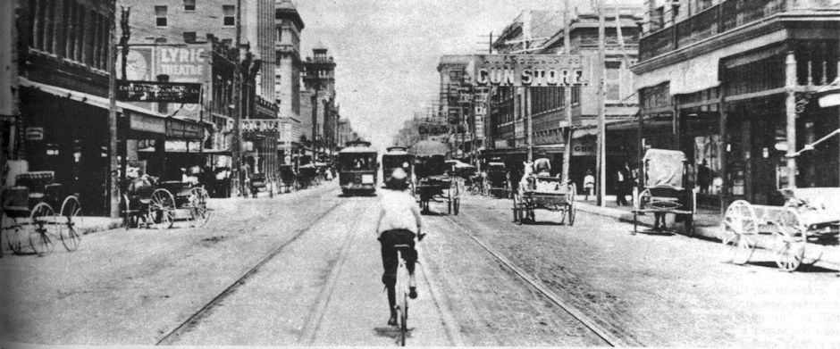
Before Fort Worth had the TRE, it had the I: the interurban. Most folks know of Northern Texas Traction Company’s interurban line that ran between Fort Worth and Dallas from 1902 to 1934.
 But on September 1, 1912 the Fort Worth Southern Traction Company began providing interurban service to Cleburne. Cars left both cities hourly from 6:30 a.m. to 8:30 p.m. For Cleburne merrymakers, there was a late car from Fort Worth at 11 p.m. Imagine how dark that mostly rural route between the two cities must have been at that hour in 1912. Clip is from the September 1 Star-Telegram.
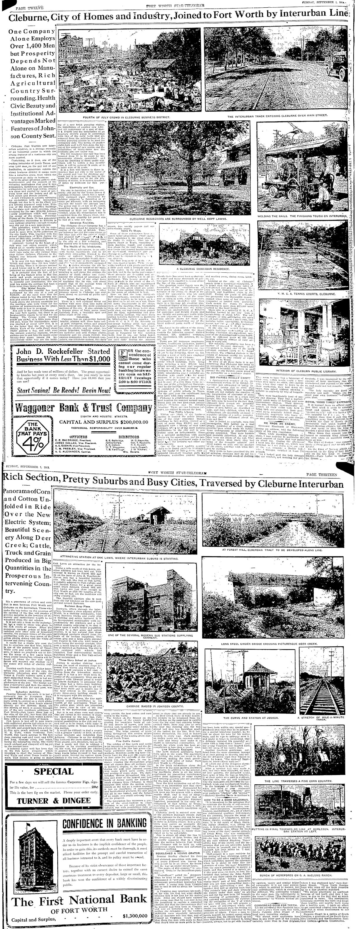 Even in 1912 the line between news and advertising could be narrow gauge. The Star-Telegram of September 1 devoted two full pages to the new service to Cleburne and to the amenities of the city itself. The bottom page has photos of one of the power substations, the passenger stations at Oak Lawn, Joshua, and Burleson, and the bridge over Deer Creek in far south Tarrant County.
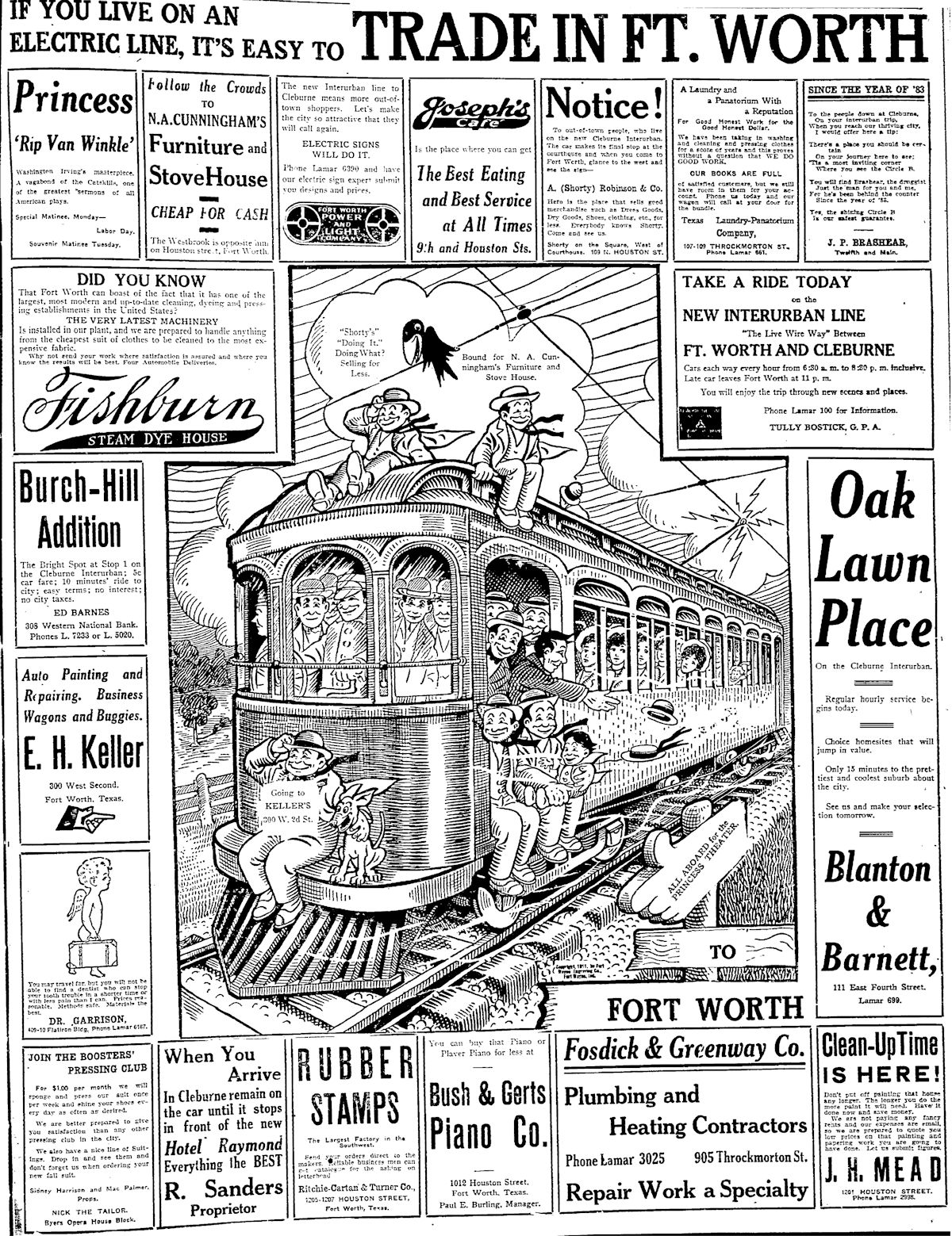 There was also a full page of ads for businesses and subdivisions (Oak Lawn Place, Burch-Hill Addition) located along the “electric lines.”
 Imagine what an advance this early form of intercity mass transit was in a time when most people did not own a car, when thirty miles was a major trip, and when sixty miles an hour was warp speed. Suddenly people could cheaply and quickly (in 1912 terms) travel between Fort Worth and Cleburne. Via connections in Dallas, Cleburne residents could go to Denison and Waco and Corsicana.
 The Cleburne interurban even ran special trains for events such as concerts and ball games.
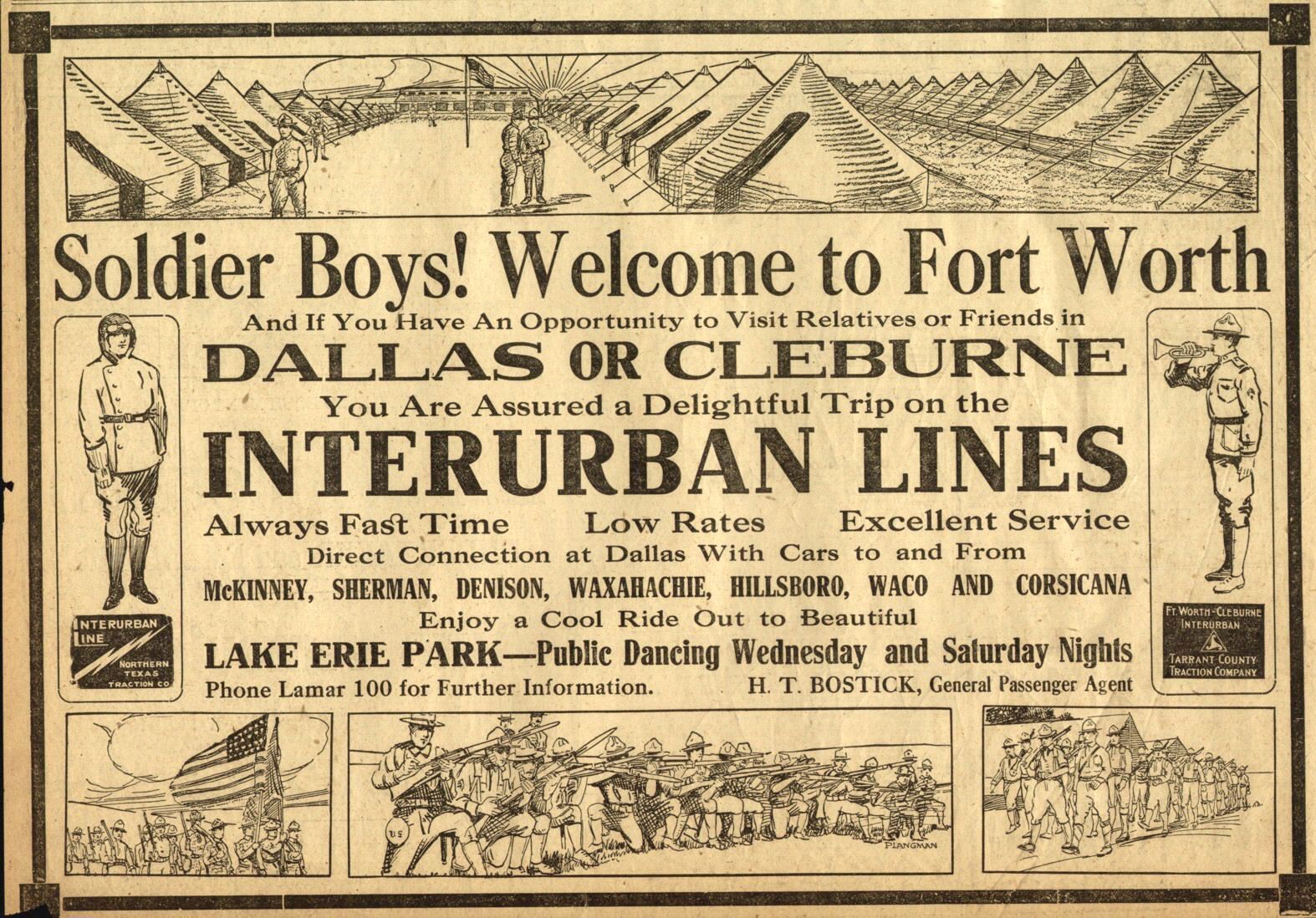 After America entered World War I and Camp Bowie opened, “soldier boys” were invited to ride the interurban lines to Dallas and to Cleburne and to enjoy Lake Erie trolley park. (Photo from Pete Charlton’s “1000+ Lost Antique Maps of Texas & the Southwest on DVD-ROM.”)
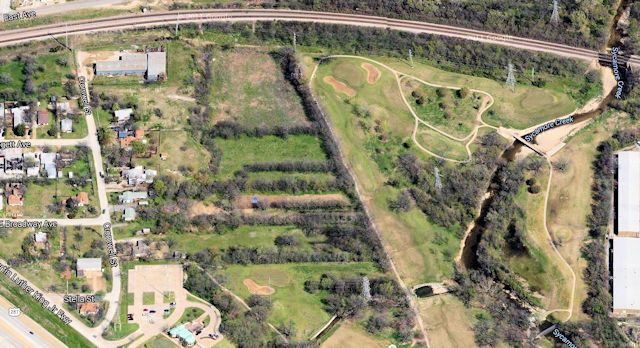 The track to Cleburne branched off Northern Texas Traction Company’s Dallas-Fort Worth interurban line at about Lancaster and Grafton streets on the East Side, passing under the Texas & Pacific tracks (top of photo) and running southeast. I suspect that the western edge (hedgerow running southeast in photo) of the Sycamore golf course follows the Cleburne interurban right-of-way.
This aerial photo from the 1930s shows the Cleburne track curving away from the Fort Worth-Dallas track along Lancaster Avenue two blocks east of Riverside Drive and passing under the Texas & Pacific tracks just north of today’s Sycamore Creek Golf Course. (Photo from University of Texas at Arlington Library.)
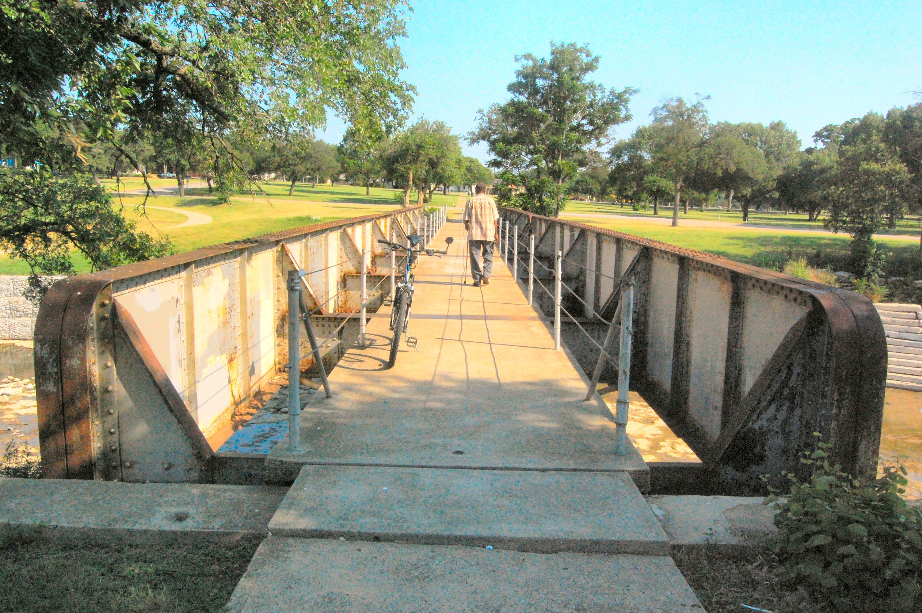 Next the track ran through Sycamore Park. The narrow iron bridge that carried the track over Sycamore Creek still stands. The bridge resembles the Deer Creek bridge in the 1912 photo above. In the last half of the twentieth century many an East Sider walked over this bridge without knowing its history, probably assuming (as I did) that the bridge was put there for the benefit of pedestrians.
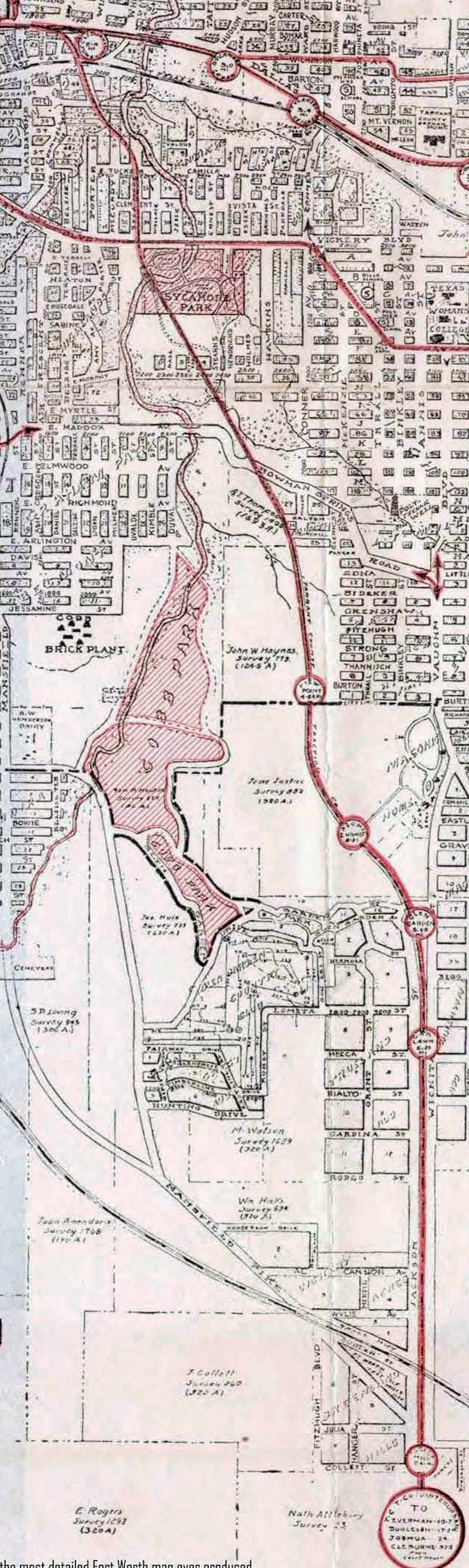 This 1925 Rogers map detail reveals a lot. The city of Polytechnic‘s waterworks was on the east side of Sycamore Park. A water well of the city of Polytechnic was located near today’s D. McRae Elementary School. Bowman Springs Road, now Burchill Road (named for Postmistress Belle Burchill, who developed the Burch-Hill subdivision), was named for the family of “12th Street Rag” composer Euday Bowman, whose family had farmed southeast of Fort Worth. Bowman Springs Road still exists in south Arlington.
South of Sycamore Park the track followed the route of today’s Mitchell Boulevard, which in the late 1930s would be built on the old Cleburne interurban right-of-way. Even in 1925 the Cleburne line ran through some of that “beautiful country” touted in the ad as the line ran south of Bowman Springs Road. The first stop on the line was View Point near Burton Street. Then came stops at Masonic Home and Glen Garden Country Club. Just below Masonic Home the track veered due south and ran alongside Wichita Street (Jackson Street then) with a stop at Oak Lawn (near today’s Oak Lawn Elementary School). There was not another stop until the line was just south of the Mansfield Pike (today’s Business 287) and the Houston & Texas Central railroad crossing: the Forest Hill stop. Note the Cobb brick plant west of Cobb Park. (Map detail from Pete Charlton’s “1000+ Lost Antique Maps of Texas & the Southwest on DVD-ROM.”)
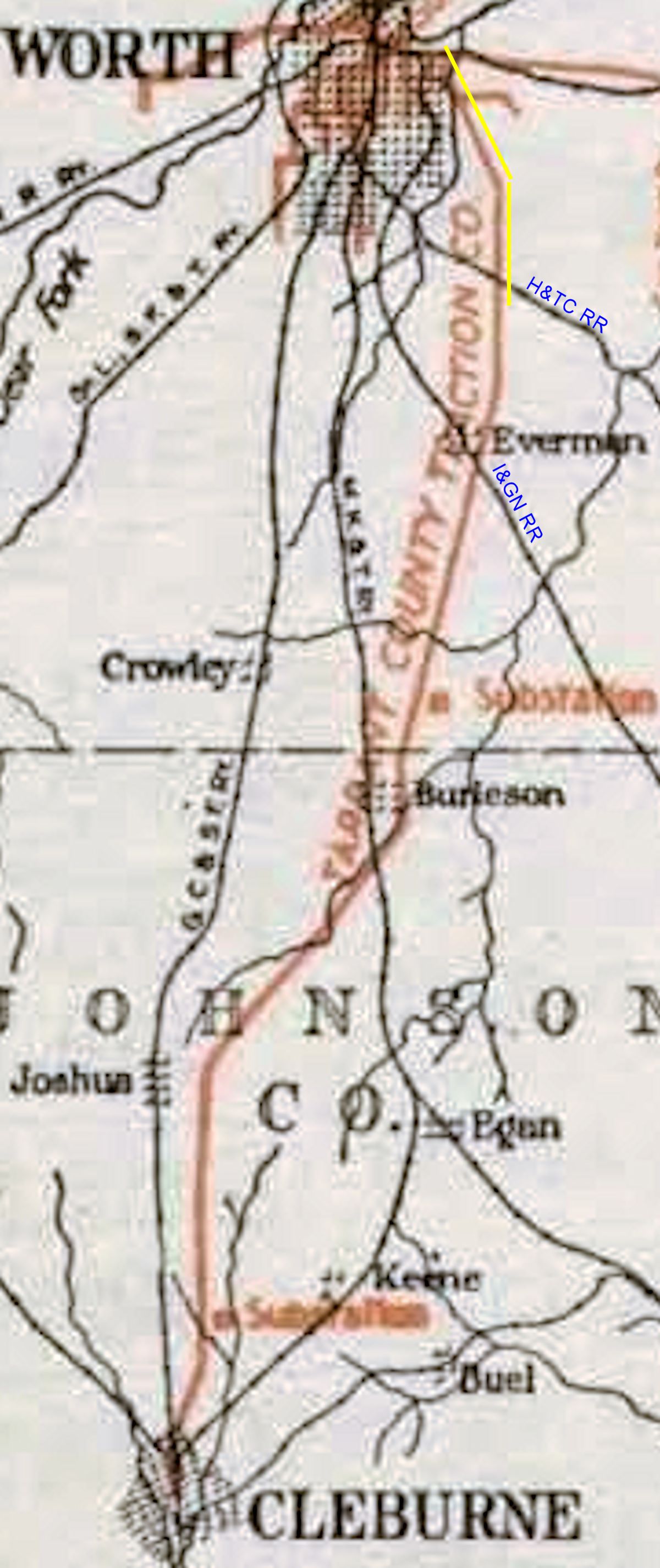
After the interurban track crossed the Houston & Texas Central tracks, it veered to the southwest and then crossed the International & Great Northern tracks. The yellow line shows the stretch of the interurban track shown in the 1925 Rogers map above. (Map detail from Pete Charlton’s “1000+ Lost Antique Maps of Texas & the Southwest on DVD-ROM.”)
The Cleburne track crossed several more creeks past Sycamore Creek. Just as with Sycamore Creek, bridges had to be built. Now, of course, all that track, all those bridges are gone.
Almost.
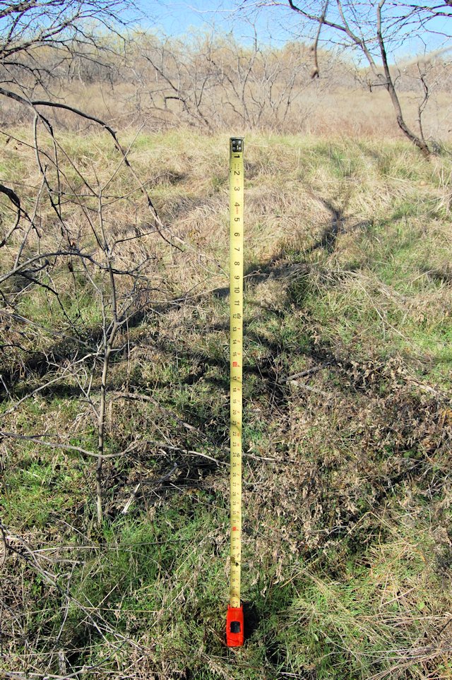
A half-mile south of where the International & Great Northern track crossed Wichita Street and the interurban track, the interurban track crossed an unnamed tributary of Village Creek. Paul Valentine, who told me that he remembered seeing years ago what apparently had once been a rail roadbed along Wichita Street, poked around in the brush at that creek and found the concrete foundations of the interurban bridge. The foundations have been hunkering there since 1931 as the world passed by on Wichita Street seventy-five feet away.
Before I went out to see this archeological discovery I studied a 1952 aerial photo and saw that there might have been an interurban bridge over another creek 1.3 miles north of the foundations that Paul found.
Sure enough, concrete foundations of two interurban bridges survive along Wichita Street. But much more of Paul’s bridge—the south bridge—survives. Three of its five concrete foundations—the two end foundations and one inside foundation—still stand. The other two have fallen and are broken. Of the north bridge only a few remnants of the foundations can be seen.
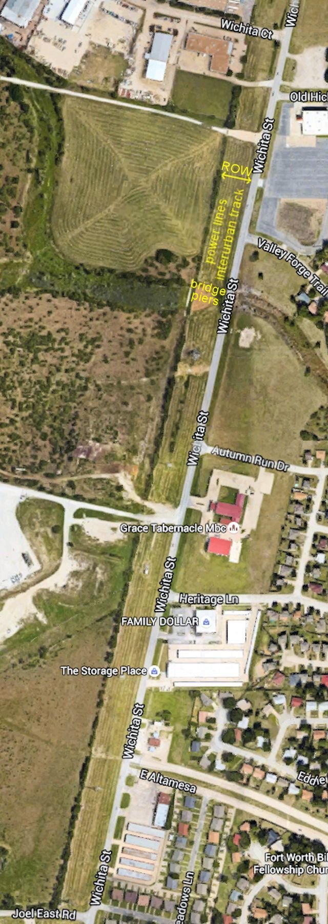 The north bridge was near today’s Valley Forge Trail. The interurban’s right-of-way along Wichita Street was about 150 feet wide. Much of that right-of-way has been developed or overgrown with brush, but open right-of-way still exists between Wichita Court and Joel East Road. In this aerial photo you can see a row of trees along the western edge of the right-of-way. The interurban track ran about midway between Wichita Street and that row of trees. The overhead power lines that today run along the right-of-way are to the west of the interurban roadbed.
 The remains of the concrete foundations of the north bridge are mostly buried.
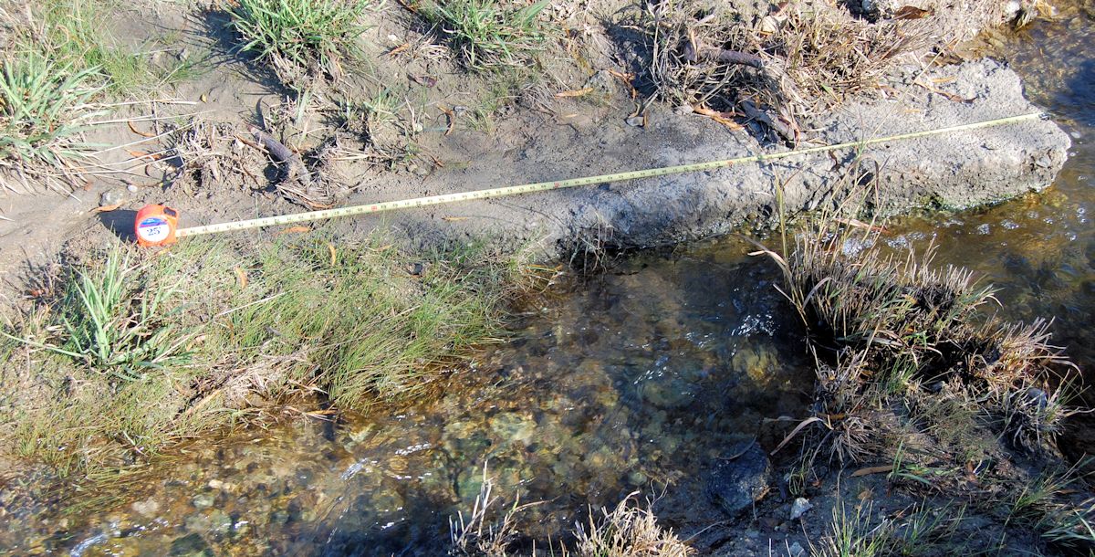
 An anchor bolt in a foundation of the north bridge.
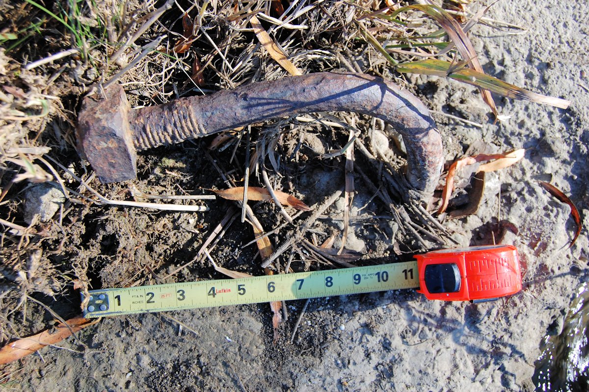
 A hefty wooden beam (a rail tie?) survives parallel to the foundation remnants of the north bridge.
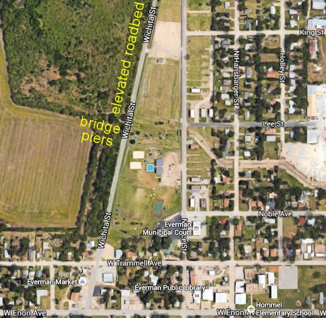 The south bridge was two blocks north of today’s Trammell Avenue opposite an Everman city park.
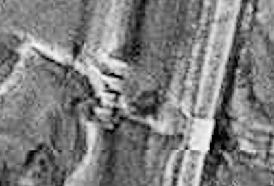 An aerial photo from 1952—twenty-one years after the Cleburne interurban shut down—shows the creek and the five concrete foundations of the south bridge.
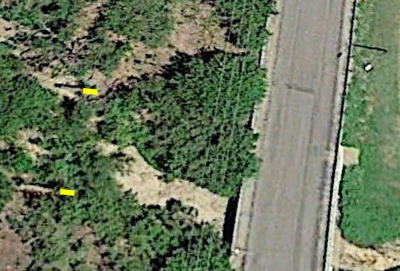 In a contemporary aerial photo the two end foundations can be seen to the left of the yellow lines.
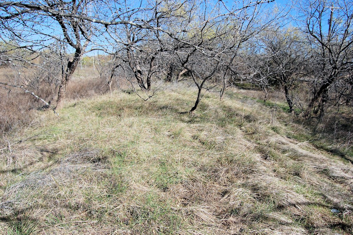 If you are willing to tangle with inhospitable barbed wire and ornery mesquite trees, the elevated roadbed that the interurban track ran atop can easily be found in the stretch of the right-of-way that has reverted to brush. No elevated roadbed survives where the right-of-way is cleared.
 The roadbed is about four feet higher than the surrounding terrain.
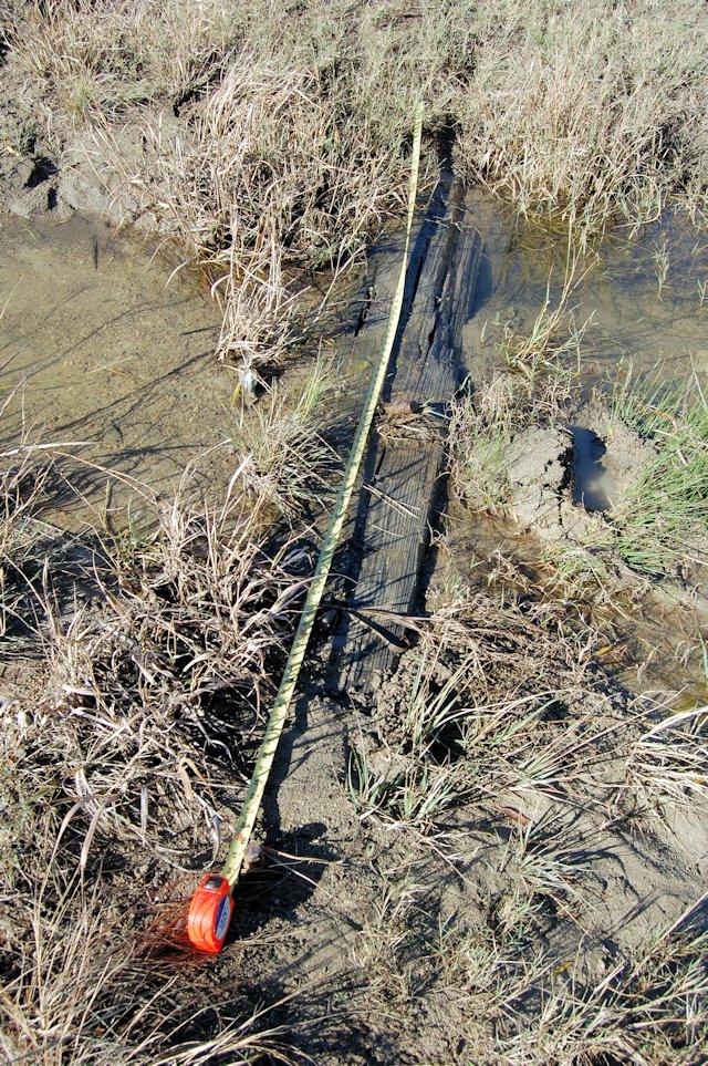
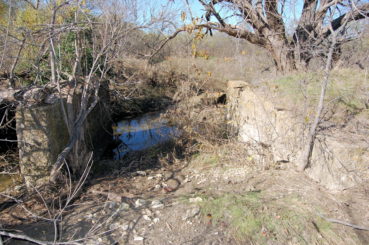 Trolleyhenge: An inside foundation (left) and an end foundation (right) of the south bridge. Two anchor bolts can be seen on the end foundation. Part of another foundation lies in the water beyond.
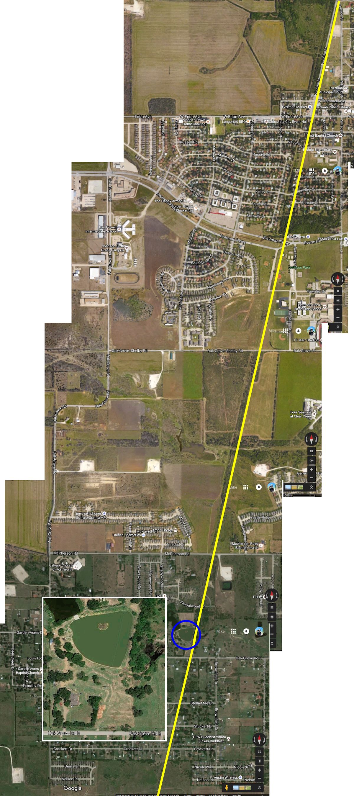 Past the end of Wichita Street at Enon Road the interurban track ran virtually straight—through open country—into Burleson, then on to Joshua and Cleburne. Just north of East Oak Grove Road is a stock tank whose dam lines up perfectly with the line of the interurban roadbed. I suspect that after the Cleburne interurban shut down, some farmer got the clever idea of using the elevated roadbed as a ready-made earthen dam. I have stitched together some aerial photos to show the line of the track from north of Enon Road. The tank has been there since at least 1952.
 Farther south, this 1999 aerial photo of the Oak Grove Airport area south of FM 1187 shows a substation of the Cleburne line and even a stretch of right-of-way of the track running southwest toward Burleson. The substation has since been demolished, not a brick of its history preserved.
 In Burleson the visitors center has on display interurban car 330 (built in 1902). The center is the old Burleson interurban depot.
 Burleson druggist Albert Loyless was the local representative of the interurban. The depot building also housed his pharmacy and soda fountain.
 In Cleburne the depot was half a block south of the courthouse.
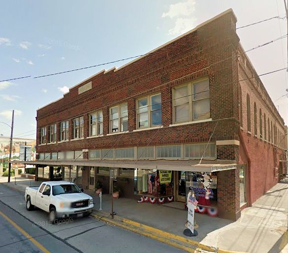 The A. J. Wright Building now houses Cowan Costumes, Inc. Wendy Pierce, Cowan sales and marketing coordinator, said, “You can still see some of the train track in the alley beside our building where they have laid the road on top of it.”
At its peak, interurban service had five hundred miles of track in Texas. Other lines connected Fort Worth and Dallas with Waco, Corsicana, Waxahachie, Terrell, and Denton. But the Depression and the increasing availability of automobiles and buses caused a decline in interurban ridership.
After nineteen years and eight million passengers, service to Cleburne was ended in 1931. Northern Texas Traction Company, which had taken over the Cleburne line, operated the Cleburne track only to the Forest Hill stop. By 1934 the NTTC interurban system was operating at a loss and closed.
End of the line.
(Thanks to Paul Valentine for his tip about the bridge foundations.)


Hello
Great info on the Interurban to Cleburne.
I bought a home in Joshua in what is now called Old Mountain Valley. My son in law also lives in this neighborhood. He backs up to Village Creek just east of 174. I believe his property has the remains of a power pole and bridge footings for the the track as it crossed the creek and moved northeast away from what is 174.
Ironically, I live about 2 blocks north along the same Village Creek and beside the Mountain Valley Golf Course’s 13th hole. There are old maps that show an “Old Railroad Grade” running along the creek through the courses back nine before it was built 1964 and north towards Burleson. If you study maps and the terrain I could swear some of the cart path is actually the old track bed. Also there is a cart bridge that looks like it could be a reused RR bridge.
Thanks
Rich
This was a great story. I am new to Cleburne, and have moved into Original Cleburne…The Cleveland addition. Love hearing about the history of my new home town!
Thanks, Kimberly. It’s a great part of local history.
Katy Operated Line a from Egan to Cleburne
Cleburne was a major railroad town at the turn of the last century (1900). A group headed by John L. Cleveland, D. E. Wagoner and S. B. Allen persuaded B. P. MacDonald and associates of Fort Scott, Kansas to construct a railroad connecting Cleburne with Missouri, Kansas and Texas Line.
This railroad completed in 1902, was named Dallas, Cleburne and Southwestern, better known as the “Katy”. A depot was built at Front and East Chambers Street with a turntable and freight yards located between East Buffalo Creek and the Dallas branch of the Santa Fe. The route of the tracks was through Keene along what is now “Old Betsy” Road, FM 2280.
In its earliest years the railroad did a considerable amount of business. Heavier equipment and additional trackage was added.
In 1910 the company was sold to the M.K.T. by 1920 reduction business on the Cleburne Egan section brought the end to the “Katy” in Cleburne, although the main line of the M.K.T. still runs through Egan in the northern part of Johnson County.
The old depot was used in later years by the F&H Oil Company as an office and warehouse.
Do you know if there was ever some type of Interurban line or maybe a railroad line running from Cleburne to possibly Ft. Worth that went just south of Egan? There is definitely an old raised bed that crosses County Road 807 and continues to run across the land south of County Road 707. It may have joined the Burlington Northern line that runs through the area. The is also a bridge remaining. My mom’s grandfather told her that when he was a boy the Interurban came through the area. The maps in this article don’t indicate that. I am just curious.
That sounds like the Katy railroad track, which runs into Fort Worth from the south, passing through Egan and over 807 and 707. You can trace the track on Google maps. Am not aware of an interurban line down there.
Hello from Cleburne. I am interested in getting a copy of the Star Telegram newspaper page about the interurban and information on Cleburne. Is it available from the Star Telegram, or do you have a scan? I’m always researching about Johnson County! Have you ever heard of Chase Park - it was near the Interurban line north of Cleburne.
Mollie, I have e-mailed you three pages from September 1, 1912.
Thanks, Mike and Paul. Lots of great information. I have seen these piers, never knew why they were there. I thought maybe an old road. It would be great to have the old car up and running again. Amon says to expect a little extra in your pay envelope.
Thanks, Earl. It was fun to explore that stretch along Wichita and see relics of the interurban. That is the only surviving raised roadbed that I am aware of.
This is terrific! Great job!
Thanks, Mike. The interurban is one of my favorite parts of Fort Worth history.
Albert Hendon “Poss” Loyless was still a deacon at the Burleson church I attended as a boy, and I was, in more recent years, a good friend to his daughter, Donna and her son Barry. NTTC approached Mr. Loyless with a proposition to build a structure from which he might operate his pharmacy if he would be the Burleson ticket agent. He agreed. Serving as everything from scoutmaster to city councilman, A. H. Loyless was fully committed to the betterment of his community and mankind in general. The orange car pictured above is the original Northern Texas Traction Company express car built by Kuhlman Company and from which 3 additional cars were modeled and which was operating on the Ft. Worth - Dallas run after 1902. The restored original is on display at the Heritage Visitor Center in downtown Burleson, TX, and contains a rail exhibit. Express Car No. 330 (once car no. 30) was shifted to the Cleburne run as it opened during the fall of 1912. To my knowledge, it is the oldest Texas interurban express car in existence today, 112 years old.
You failed to mention, if known, the fare for a trip to Cleburne, and maybe compare it to the fare we pay on the TRE.
Bryan, all I found was that the Northern Texas Traction fare was seven cents (free transfers) in 1920-about seventy-five cents today. In 1922 the city of Fort Worth went to court to try to get the fare reduced to a nickel.
Which line is the car at the ITC from? Yes, the car in the photo in the linked post at http://dfwptp.blogspot.com/2011/05/wet-and-lost-on-bike-to-work-day.html
I believe the ITC Crimson Limited car ran FW-Dallas. The Burleson car ran FW-Dallas, then FW-Cleburne, then FW-Dallas.