Before Grand Prairie had its Lone Star Park, Arlington had its Arlington Downs. And before Arlington had its Arlington Downs, Fort Worth had its driving park, where people raced and bet.
 An 1886 bird’s-eye-view map of Fort Worth shows the “North End and Driving Park” in the Samuels Avenue neighborhood (see Part 1). That oval is the driving park’s track.
 Here is a closeup of the driving park, which was located about where a county jail facility is today on Cold Springs Road. That building with two cupolas northwest of the track was the Rosedale Pavilion (see Part 3). Rosedale Pavilion was Fort Worth’s first trolley park. The Rosedale streetcar track was laid down the middle of Pavilion Street (which still exists) and ran beside the pavilion and ended at the driving park.
 On March 21, 1883 the Fort Worth Driving Park Association filed its charter. Among the men who opened the new driving park were attorney and real estate speculator Robert McCart (as in the South Side street); former mayor G. H. Day; Jake Johnson, a gambler who was Luke Short’s partner in the White Elephant saloon; and J. T. Wilkes and George L. Gause, who were partners in a livery stable and undertaking parlor. The middle clip indicates that an earlier race track had existed near Pioneers Rest Cemetery. J. P. Woods sold land for the 1883 park to the association. Today Woods Avenue runs parallel to the railroad track.
 For the grand opening of the driving park, the Texas & Pacific railroad operated special trains to bring race fans from Dallas.
The driving park opened on November 20, 1883. Among the owners of horses were Robert McCart and undertakers George Gause and J. T. Wilkes. Jim Courtright thanked folks for leaving their dogs at home. Clip is from the November 21 Gazette.
 Horse racing wasn’t the only sport offered at the driving park. In 1885 former tugboat captain James Dalton fought John Clow in a prize fight. There were also baseball games and shooting matches.
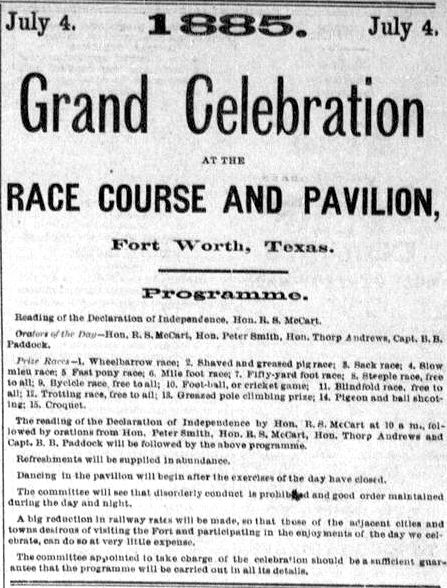 On June 6, 1885 the Gazette announced a grand celebration at the driving park on July 4. Robert McCart would read the Declaration of Independence. Orators would include John Peter Smith and B. B. Paddock. Races would include wheelbarrow, greased pig, blindfold, pony, and sack.
 All that blood, sweat, and gunpowder brought a lot of men to the Samuels Avenue area. An enterprising woman named “Frankie Brown” gave men another outlet for all that testosterone: She opened a brothel in a two-story brick “steamboat gothic” house on Cold Springs Road where Ripley Arnold Park is today. Pioneers Rest Cemetery can be seen on the left edge of the image.
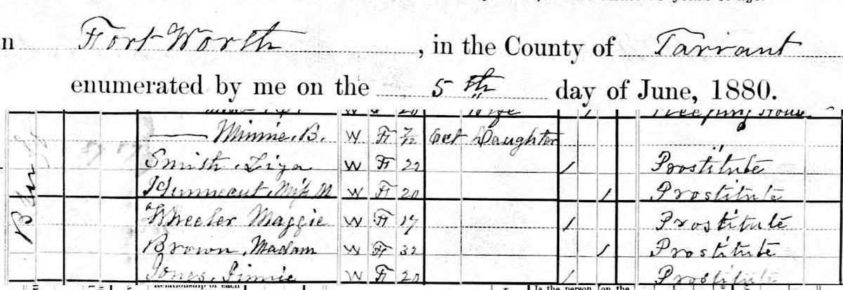 Madam Brown and colleagues were listed on Bluff Street in the 1880 census.
 In 1886 Madam Brown was fined for keeping a “disorderly house.” But about 1889 the driving park closed, and so did the brothel.
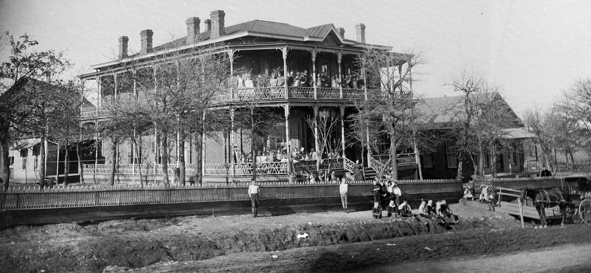 About 1890 Madam Brown’s house was converted into the Fort Worth Benevolent Home for orphans. About 1908 the orphanage moved to the East Side. (Photo from UTA Libraries.)
This clip from 1902 shows that Fort Worth would have other driving parks. Prospect Park was north of Hermann Park on the near North Side. By 1902 motor vehicles were still very rare, so “roadsters” surely were of the horse-drawn variety.
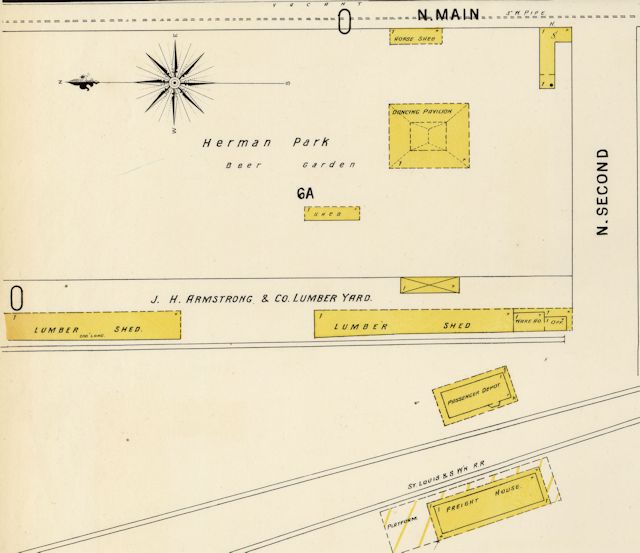 Hermann Park, an early site of Maifest, was located at North 2nd Street between North Main and the Cotton Belt tracks, near where the power plant would be in 1912.
Prospect Park opened in 1902. It probably became the motor speedway stadium (for motorcycles) that opened in 1919 and is shown on this map. Just to the north was the home of the Fort Worth Panthers/Cats before the team moved across Main Street to LaGrave Field. (Map detail from Pete Charlton’s “1000+ Lost Antique Maps of Texas & the Southwest on DVD-ROM.”)
 And in 1905 still another driving park, with seating for almost two thousand people, opened just north of where the Montgomery Ward store would be built in 1928 on West 7th Street. In 1905 West 7th Street was called “Arlington Heights Boulevard.”
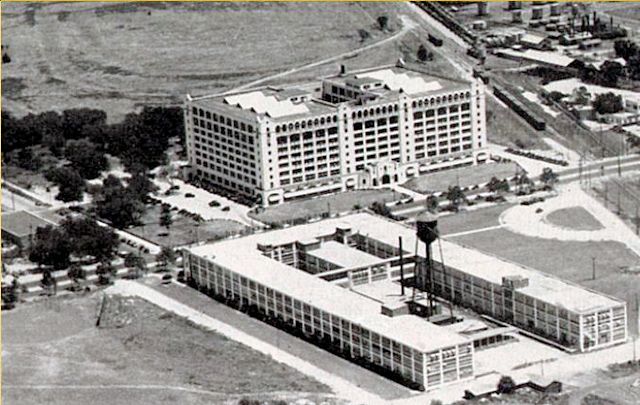 The oval of the West 7th Street driving park can be seen behind the Montgomery Ward store in this photo that appeared in the 1930 TCU yearbook. The building in the foreground is the 1916 Chevrolet plant. (Scan by Pete Charlton.)
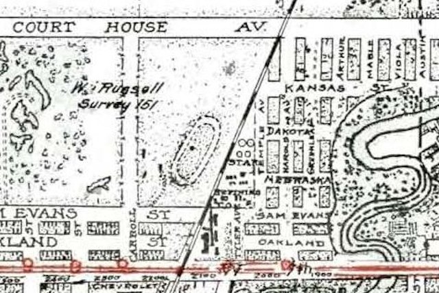 This 1925 map shows the driving park between West 7th Street and Court House Avenue (now “White Settlement Road”). (Map detail from Pete Charlton’s “1000+ Lost Antique Maps of Texas & the Southwest on DVD-ROM.”)
Like the Samuels Avenue driving park, the new driving park on West 7th offered more than horse riding and racing: rodeo events, motorcycle and auto races.
And at least one head-on locomotive collision. In 1907 “Head-On Joe” Connolly, who staged more than seventy such collisions across the country, came to town with steam locomotives no. 13 and no. 23 and crashed the two iron behemoths into each other at forty miles per hour as more than twenty thousand people watched.
 Fast-forward four years. Locomotives were no longer the fastest thing going. In January 1911 an air show featured the French daredevil Roland Garros (pictured), who made Fort Worth’s first powered flight during that show. Garros would be shot down and killed in World War I.
The driving park closed about 1920.