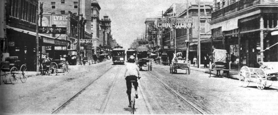
This was the big one, the one that people have seen documented in news photos and film, heard about from parents or grandparents, maybe even experienced firsthand. This was the “ain’t gonna take it anymore,” “enough is enough,” last-straw flood that brought about change after a century of intermittent catastrophes wrought by the natural resource that had been a major factor in Major Ripley Arnold’s selection of a site for the Army’s Fort Worth in 1849.
During the night of May 16-17, 1949, as Fort Worth neared its centennial, six to twelve inches of rain fell on the upper Trinity River basin, including Fort Worth.
On May 17 Fort Worth suffered what many consider to be its worst flood ever, surpassing the flood of 1889, the flood of 1908, the flood of 1922, the flood of 1989.
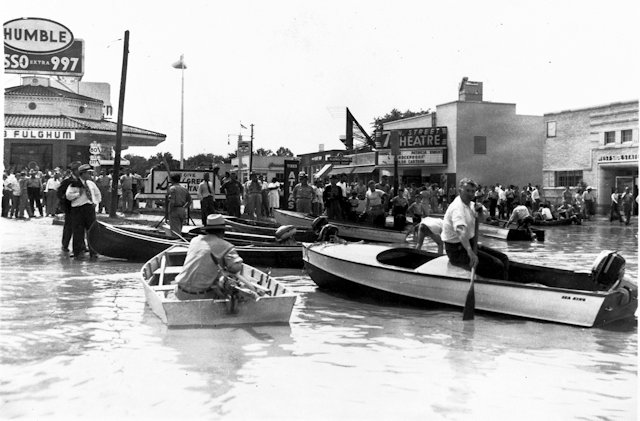
On May 17, 1949 rooftops became islands. Underpasses became swimming holes. Motorboats replaced automobiles as modes of transportation as streets became canals. Residents woke that morning to find that Fort Worth suddenly was Venice-on-the-Cross Timbers.
The intersection of University Drive and West 7th Street. (Photo from University of Texas at Arlington Libraries W. D. Smith Commercial Photography Collection.)
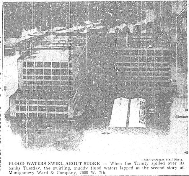 Flooding was worst on the west and north sides of town. Traditionally the point of reference for the high-water mark of the flood of forty-nine has been the Montgomery Ward building on West 7th Street. “Water stood almost to the second floor,” the Morning News reported. Water “lapped at the second floor” and “Water rose to the second floor,” the Star-Telegram reported on May 18.
Across West 7th Street, workers on the second floor of the old Chevrolet plant were rescued by motorboat.
Elsewhere, as Trinity tributary Farmer’s Branch creek flooded homes in nearby Liberator Village, Carswell Air Force Base dispatched one hundred military police officers to the flood zones to discourage looting. Police Chief Robert Dysert reported “some” looting. The West 7th Street bridge and Lancaster Avenue bridge were closed as wooden houses that had been swept off their foundations floated down the river and snagged on the pilings of the bridges. The Star-Telegram reported that the West 7th Street bridge “trembled” as floating houses smashed into its pilings. Chief Dysert estimated that one-tenth of Fort Worth was under water. Property damage was estimated at $11 million ($104 million today). The Red Cross estimated that thirteen thousand people were homeless. (Fort Worth’s population was about 270,000.) Schools, churches, Will Rogers Coliseum, Carswell all became shelters for refugees. The state rushed ten thousand units of typhoid vaccine to Fort Worth. City-County Hospital at 4th and Jones streets became an inoculation center. Water fountains at schools were turned off, and school cafeterias boiled drinking water. Students were asked to bring boiled water in Thermos bottles for drinking.
 This photo shows Lake West Side: The West 7th and Lancaster street bridges and the ever-besieged Holly city waterworks are in the upper left, Montgomery Ward and the old Chevy plant are in the upper right. Roughly centered in the photo from left to right, a line of utility poles marks White Settlement Road. The flat roofs of commercial buildings look like floating tennis courts. (Photo from Lockheed Martin.)
 This photo, taken over Riverside, shows the flooding east of downtown. That’s Belknap Street running almost north to south. The cross-shaped building on the left is the Prince Hall Grand Lodge Mosque. Greenway Park on the other side of Belknap is under water. The smokestacks of the power plant can be seen in the curve of the river in the distance. (Photo from Tarrant County College NE.)
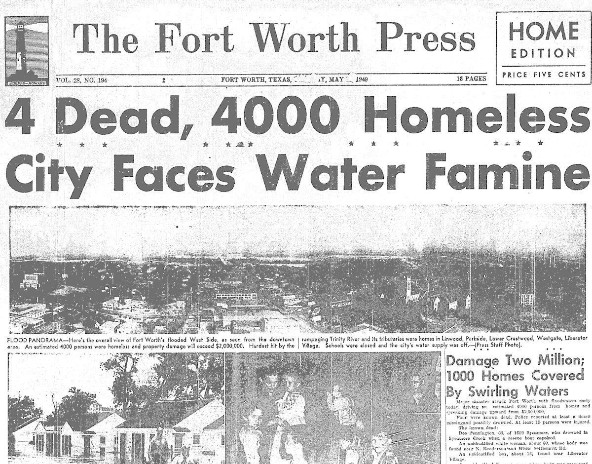 Front page of the Fort Worth Press on May 17 gave an early assessment of the flood. The numbers for the damages, homeless, and dead would rise as the floodwater rose.
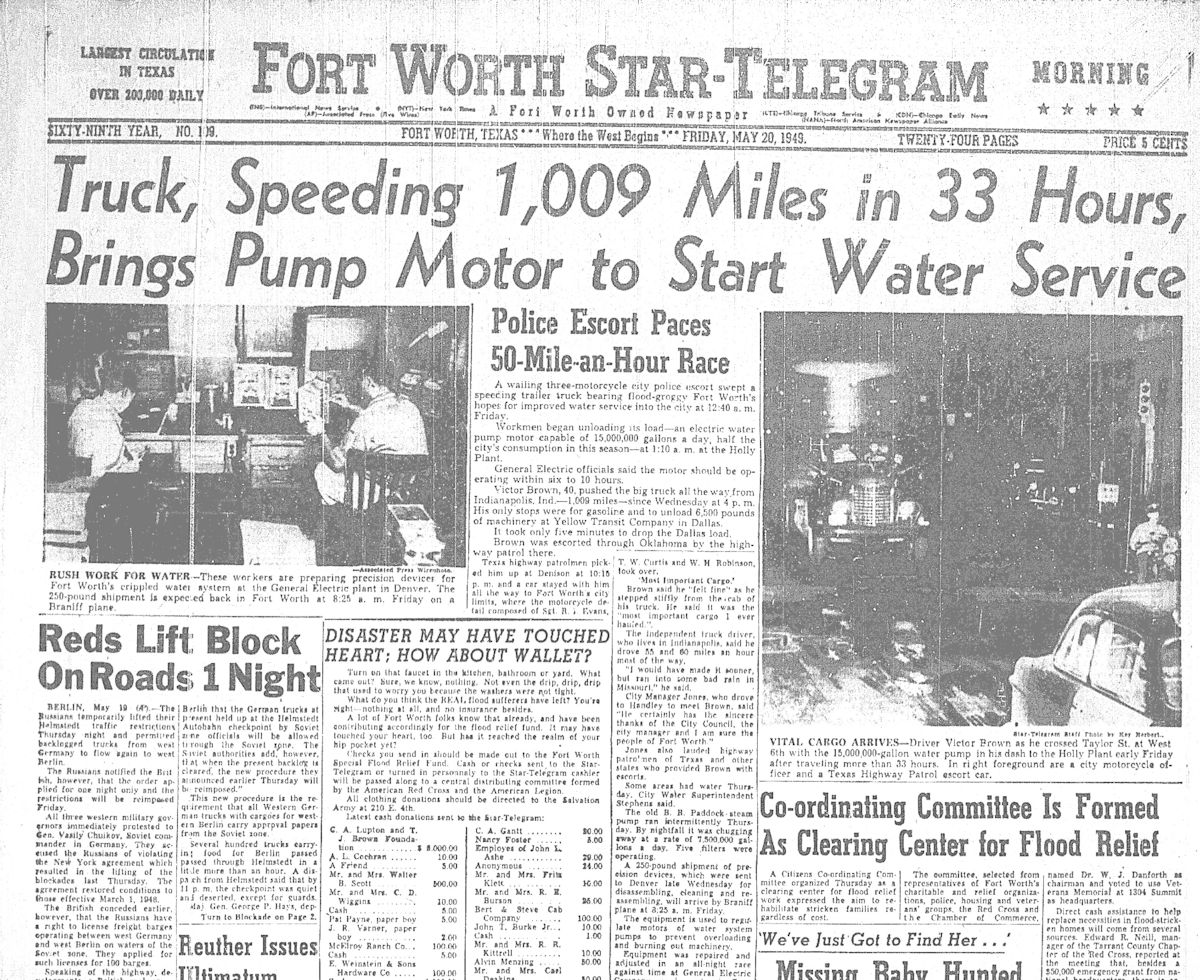 Fort Worth’s water treatment plant, with its riverside location, was always at risk of flooding. Floodwater knocked out pumps at the plant. The water department even brought a steam-powered pump out of retirement. On May 20 the Star-Telegram reported that a replacement water pump motor had been rushed—with a law enforcement escort—from Indiana. The city’s water supply was restricted for four days. The city closed municipal swimming pools, holding their water in reserve for the fire department.
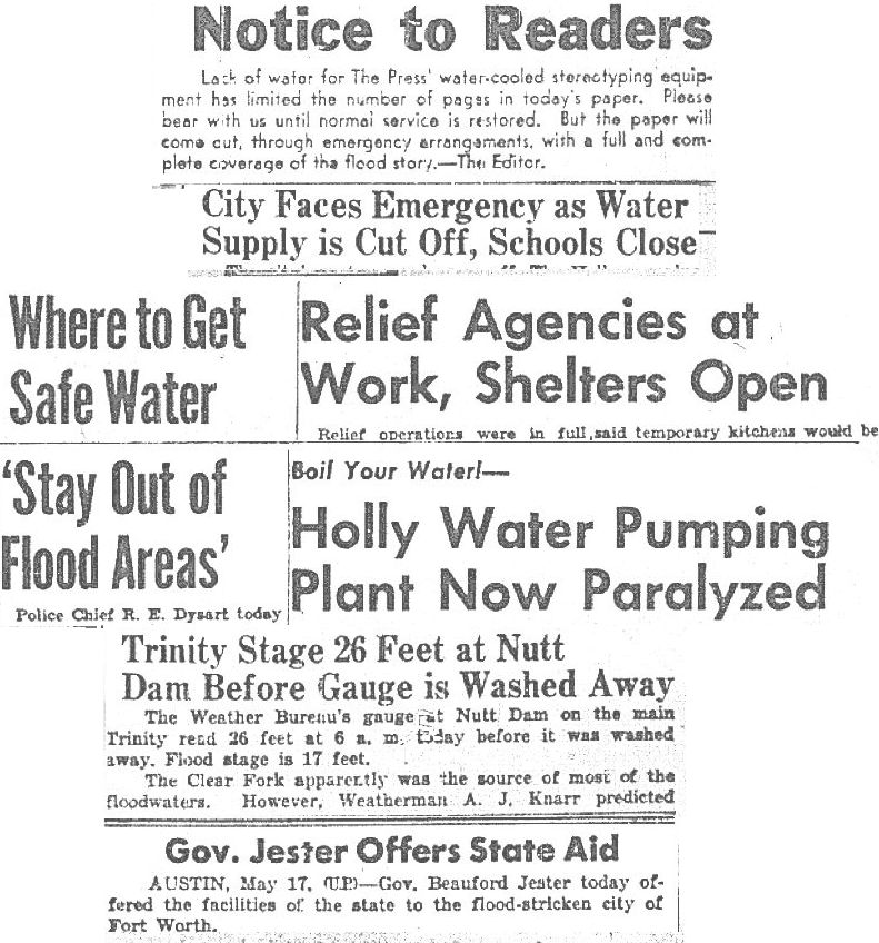 More front-page headlines of the May 17 Press. Ironically, with water literally everywhere, finding safe drinking water was a challenge. Lack of water also restricted the output of the Press and shut down public schools. The rain gauge at Nutt Dam on the Trinity was swept away. The Clear Fork of the Trinity was the main source of floodwater.
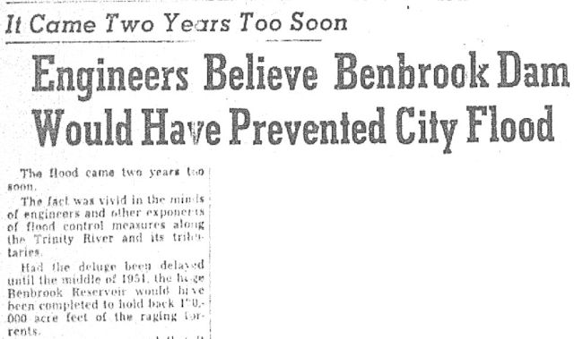 The Star-Telegram reported that engineers said that the dam of Benbrook Lake—still under construction on the Clear Fork—would have prevented the flood. Dams upstream on the West Fork (Bridgeport, Eagle Mountain, Lake Worth) were mostly effective in preventing flooding from that fork of the river.
 These are the front page headlines of the Star-Telegram and Press of May 18.
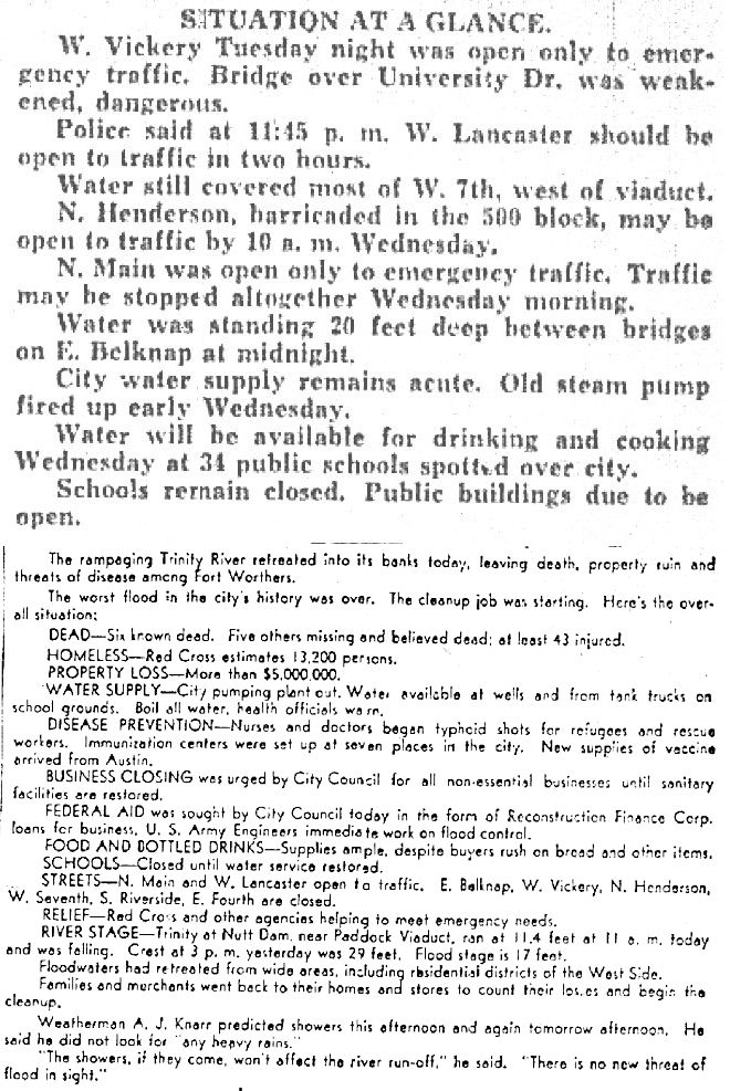 On May 18 both newspapers provided these summaries in their page 1 lead stories.
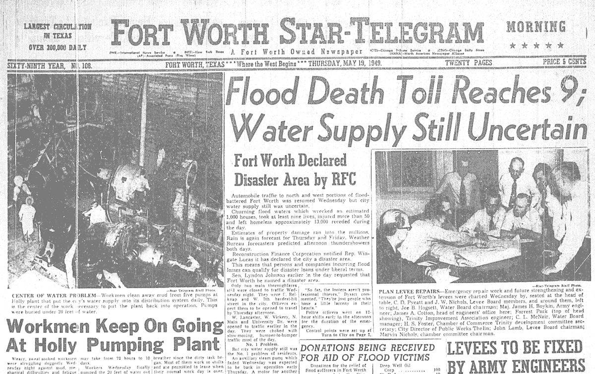 Front page of the Star-Telegram on May 19.
 Behind Montgomery Ward a horse sought higher ground. (Photo from Tarrant County College NE.)
WBAP-TV news film of the flood of forty-nine:
More Channel 5 film of the flood of forty-nine:
 The headlines, photos, and statistics are incredible. But the stories of individuals are more so. One family was burned out one day and washed out the next. This clip is from the Sweetwater Reporter.
Ed Warren, seventy-seven years old and blind, perched in a treetop for several hours before he was rescued. But Dee Pennington, sixty-eight, who had been rescued by two police officers in a boat, drowned when the boat capsized. In Forest Park Mrs. Jose Kent, eighty, clung to a Ferris wheel but was swept away and drowned.
Things could have been even worse. An official at the zoo said, “If the water had risen two feet deeper, there would have been 10-foot alligators swimming all over town.”
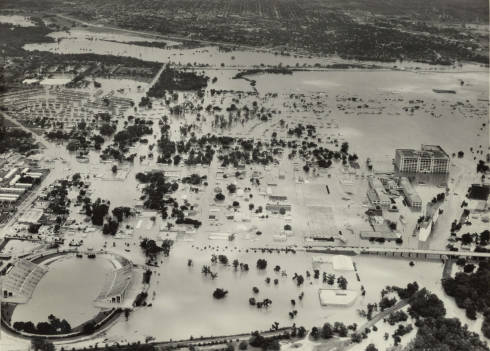
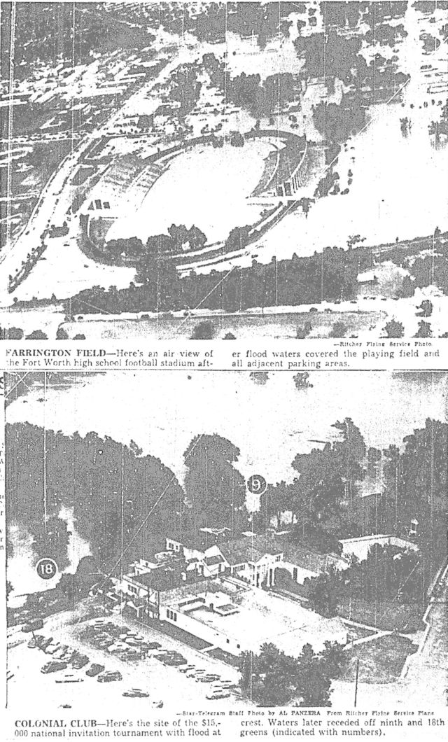 Colonial Country Club’s golf course, located beside the Clear Fork, also flooded. As did Farrington Field, which became a giant wading pool. At nearby Parkside Village, built as temporary housing for veterans, only twenty-five of three hundred housing units were not submerged. The Star-Telegram reported that floodwater was “lapping benignly at headstones” at Greenwood Cemetery. Across the West Fork, Rockwood golf course was under water. LaGrave Field, home of the Fort Worth Cats, suffered, like the Terry family mentioned earlier, a double indignity: On May 15 LaGrave Field’s main grandstand was destroyed by fire. On May 16 the field was flooded by the nearby river.
Shortly after the flood the city of Fort Worth published an “album” of aerial photos:
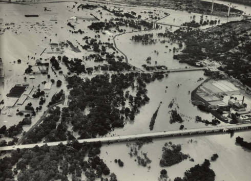
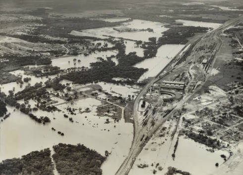
West Side from Farrington Field and Bailey Avenue east to Montgomery Ward and the Chevrolet plant.
 West Side from Trinity Park east across the Clear Fork to the waterworks. The three bridges, from bottom, are Lancaster, West 7th, and Henderson Street.
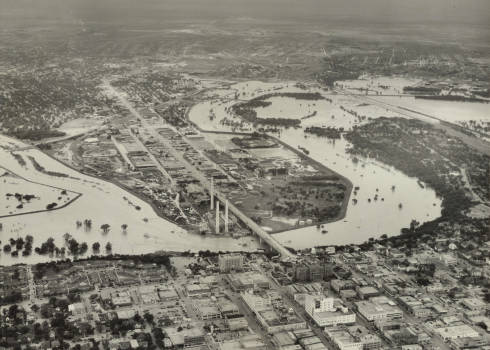 North Side from the confluence east to Samuels Avenue. Ripley Arnold public housing project is in the lower left. In the center the power plant can be seen next to the Paddock viaduct.
 North Side from the power plant and viaduct east to the “Three Sisters” railroad bridges near the Samuels Avenue bridge.
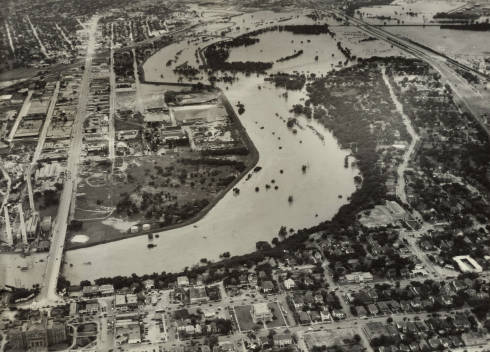
 Stockyards with flooded Marine Creek. East Exchange Avenue is in the lower left, North Main Street is on the lower right.
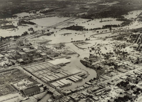
 Texas & Pacific’s Lancaster yards southwest of downtown. The flooded Clear Fork is on the left.
![]()
Looking west over the flooded Clear Fork. (Photo from Jack White Photograph Collection, University of Texas at Arlington Libraries.)
 The Press on May 17 and the Star-Telegram on May 18 said the flood of 1949 was worse than the flood of 1922.
The Star-Telegram reported that ten people died in 1949. A historical marker on the river puts the death toll at eleven.
 As had the floods of 1889, 1908, and 1922, the flood of 1949 led to flood-control measures. Fort Worth received an emergency federal appropriation to build a floodway. Voters approved a $7 million bond issue to finance levee improvements and to create Marine Creek Lake and Cement Creek Lake in the watershed of Marine Creek, a tributary of the Trinity. Clip is from the Dallas Morning News.
The water district and the Army Corps of Engineers took charge of an extensive makeover of the river during the 1950s and 1960s: In addition to the creation of lakes (such as Benbrook) and sturdier levees, the river channel was straightened and widened. Remnants of the old channel can still be seen on the west, north, and east sides of town.
 In April 1956 Fort Worth’s Trinity River floodway was dedicated in ceremonies attended by a freshman U.S. representative named “Jim Wright.” Clip is from the Dallas Morning News.
Forty years later, to the day:
Deja Deluge: Forty Years On, the Flood of 1989
And in May of 2015:
Come What May: 35 Trillion Gallons of Rain
Wet and Wild: One of Our Waterfalls Is Missing
More posts about weather:
“Greatest Tragedy of the Century” (Part 1): “Dead Outnumbers the Living”
Winter 1930: Lake Worth Ice Capades
The Deep Freeze of Fifty-One
Texas Toast: The Summers of 1980 and 2011
The Flood of 1889: The First of the Big Four
Double Trouble: The Twofer Flood of 1915
From Beneficial to Torrential: The Flood of Twenty-Two
Deja Deluge: Forty Years On, the Flood of 1989


This was a terrible tragedy for My Beloved Fort Worth. I Was Born in 1950, My Sister in 1948. We lived in Stop Six. I Don’t know What The Damages Were, If Any???
Pingback: Epic Flooding. How Much Is Too Much? - BMS CAT
Roger, a quick check of Ancestry.com shows that Asher was born in Kentucky. Cy was born and raised in Wise County and later was mayor of Azle. Jim Wright called him “the mayor of mayors.” I see no relation between Asher and Cy so far.
I was 4 years old. We lived in River Oaks, but on “high ground.” What I remember most is getting shots at Pioneer Palace and the rusty/muddy water coming out of our water faucets. Oh, and of course seeing Monkey Wards under water to the second floor a couple of days later.
I was in second grade when the food of 1949 went over our house on Wingate. When we were awakened by a loud speaker, we gathered up a few clothes and our dog, Lassie. We drove to the highest level on the street and parked. My dad went back for our other car but the water was up to his chest and he swam back. We lost everything except a cedar chest that mother had just purchased. Some friends in Olney, Texas, sent me two dolls and some hand-me-down clothes. We were safe. And the rest didn’t matter. We moved to higher ground.
I came across several photos of my mom’s marked “Flood of ’49.” I had no idea where the flood had occurred. This was the 1st website I came across. Thanks for the info.
Thanks for all this info on the ’49 flood. What was the difference between the flood of ’39 and the flood of ’49?
Thank you, Ms. Simcox. Fort Worth’s marriage with its river has been a petulant one. But I am not familiar with the flood of 1939. There was a flash flood on the upper Colorado River at Snyder in June 1939 and some flooding at Big Spring, but the most rain Fort Worth received in any month in 1939 was 4.04 inches in June. In contrast, Fort Worth received 10.64 inches of rain in May 1949, and the upper Trinity River received six to twelves inches on just May 16-17.