If you are familiar with the East Side, you probably are familiar with these two roads:
Ederville Road and Handley Ederville Road. “Handley” refers to Major James Madison Handley.
But who was the Eder in “Ederville”?
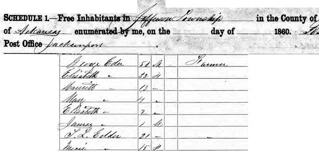
George Eder was born in Pennsylvania in 1810. He farmed for many years in Jackson County, Arkansas. In 1854 he married Elizabeth Steen, who was eighteen years his junior. By 1860 they had six children (three probably from a previous marriage). About 1871 the Eders moved to Tarrant County, where George bought a farm a mile or so north of Handley. One day he dug a well and discovered that the water therein had a healthful mineral content. Other wells were dug. Word spread. A hotel was built at “Eder’s Wells” to accommodate people who came to “take the waters.” The hotel had two stories, fourteen rooms, and separate mineral water baths for men and women.
Enter Joseph S. (“Buckskin Joe”) Works, who wore his hair long and dressed in a buckskin shirt. Works was a “professional booster,” an entrepreneur who traveled around “colonizing” settlements during the late nineteenth century as railroads spread and as states such as Texas and Oklahoma were settled by immigrants.
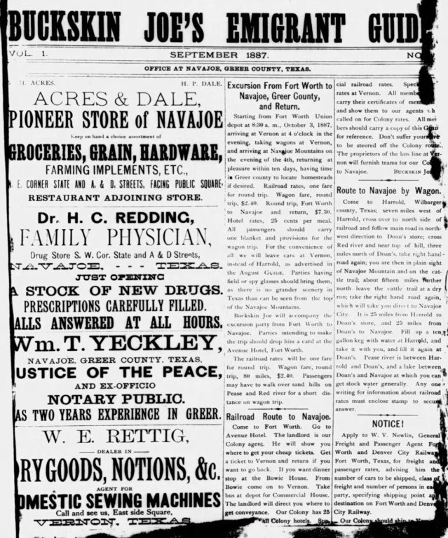 His MO was to acquire land, lay out a townsite, and promote sales of lots in the new town with his emigrant guides and train excursions from big cities. For example, in 1887 he published an emigrant guide for his town of Navajoe in Greer County on the Red River. He offered excursion trains from Fort Worth for prospective buyers.
About the time Buckskin Joe was promoting Navajoe, he was given ninety acres of land near George Eder’s farm in return for helping to establish colonies along the Fort Worth & Denver railroad. Buckskin Joe looked at Eder’s mineral water wells and the thriving hotel and felt they deserved their own town.
![]()
So, about 1882 Works platted his ninety acres, began selling lots, and named his settlement “Ederville” to capitalize on the name recognition of George Eder’s popular mineral water.
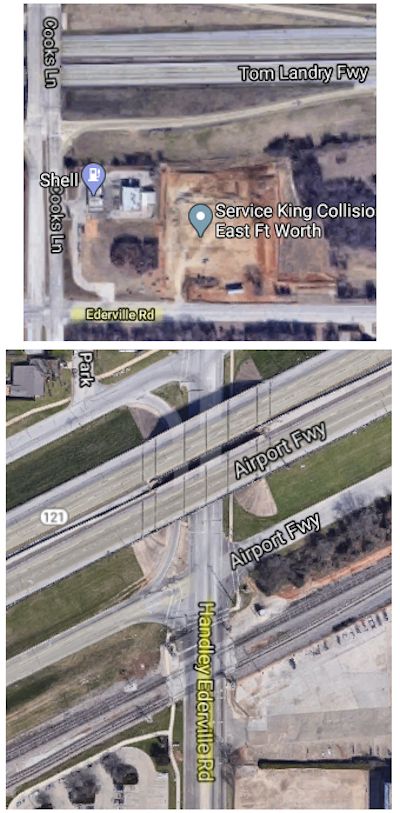
In turn, the hotel took the name of Buckskin Joe’s new settlement. Ederville was located about where East Loop 820 and Interstate 30 intersect today. Today near that intersection is a street named “Works.”
In 1975 former Ederville resident Johnnie Lilla Farrell (born 1902) recalled the settlement.
“George Eder dug the [first] well about 1875. The water was drawn from the wells by hand, heated, and mudpacks made. The deepest well produced a pound of crystals for every nine gallons of water. . . . I’ve heard my mother say that people would come and stay in tents for treatment of arthritis, that she saw them get up and walk away.”
In addition to the hotel, Farrell recalled, Ederville in its prime had a nine-grade school, pavilion, skating rink, post office, blacksmith, saloon, church, and drugstore. She said her grandfather, Reverend Washington Marion Isham, once owned the hotel.
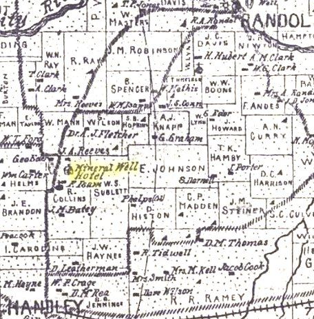 An 1895 map shows the “mineral well hotel” north of Handley. (Map from Pete Charlton’s “1000+ Lost Antique Maps of Texas & the Southwest on DVD-ROM.”)
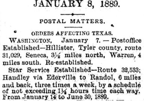
In 1889 Ederville became a stop on a new Star Route. Star Routes were part of the nation’s network for mail delivery. The Post Office Department hired contractors for these routes and allowed them to use any form of transportation they chose to carry the mail. The 1895 map shows a road from Handley (lower left) north to near the Ederville Hotel and then east to Randol (as in Randol Mill).
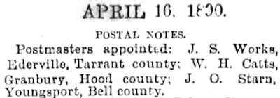 In fact, in 1890 Buckskin Joe himself was appointed postmaster at Ederville.
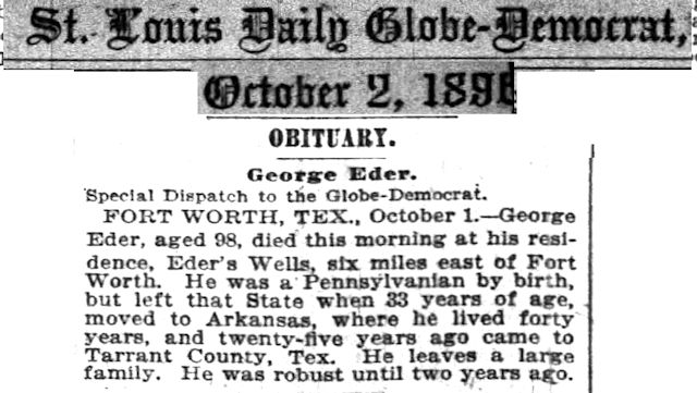 George Eder died in 1896.
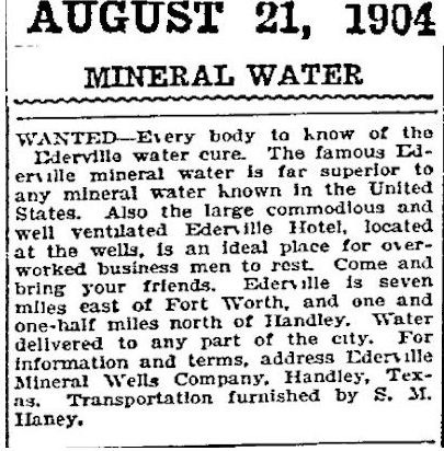
George Eder was gone, but the Ederville story continued. By 1904 the Ederville Mineral Wells Company was advertising the “Ederville water cure” and the Ederville Hotel and offering to deliver water to Fort Worth.
Johnnie Lilla Farrell recalled that “Ederville was a popular place in the 1890s, but it went downhill after 1913.”
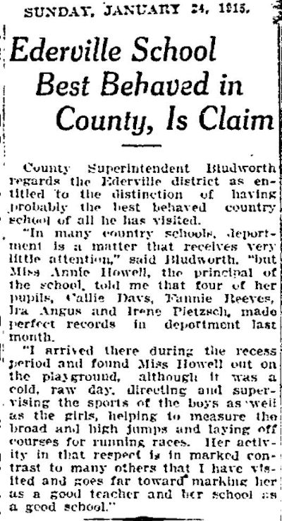 In 1915 the superintendent of county schools praised the Ederville school as “probably the best behaved country school of all he has visited.”
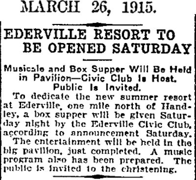 And in 1915 Ederville got a “new summer resort” and a new pavilion. But the revival was short-lived. George Eder’s healthful wells dried up, and Ederville’s raison d’etre evaporated.
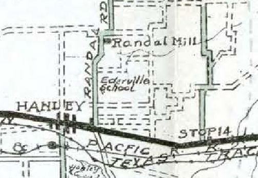 By 1920 only the Ederville school was shown on a county map. (Stop 14 was a stop on the Interurban line to Dallas.)
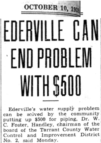
By 1938, ironically, the town founded on water was suffering a water shortage. The county water district offered to pipe water to Ederville.
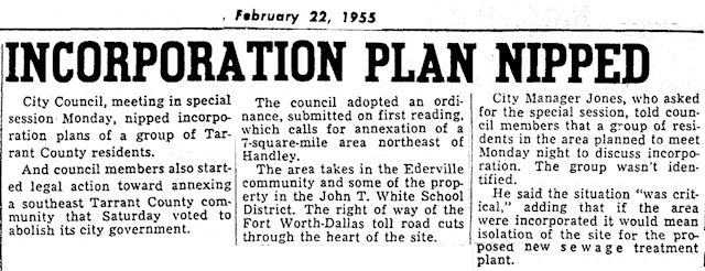 This Star-Telegram report is vague, but in 1955 Fort Worth annexed Ederville as the turnpike (I-30 today) and Village Creek sewage treatment plant were being planned. Today the town named for George Eder lives on only as two street names.
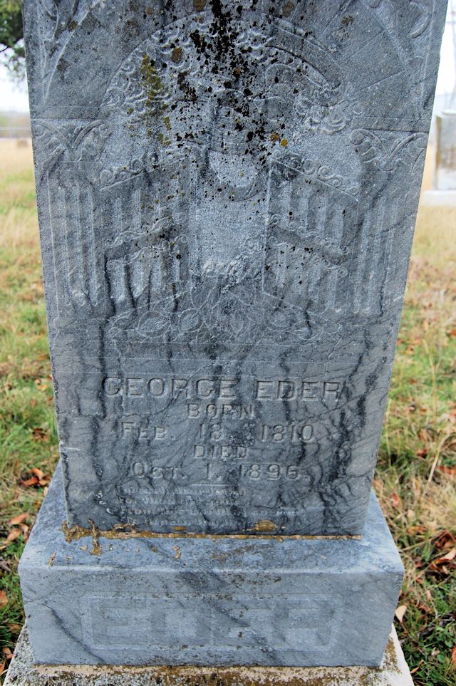 George Eder is buried in the cemetery named for the other man in “Handley Ederville Road”: Handley Cemetery.


Thank you for taking the time to write this article on Hanley and Ederville. I like that I am able to read this and learn the history of places like this.
Thanks, Lorelei. I grew up on the East Side and was glad to learn more about the origin of its place names.
I know, in looking through several of these sites, I saw the name of an actual mayor of Ederville, but for the life of me I can’t find it again. Does anyone know this name or a website?
Thanks!
Hello,
Joseph Works is my Great Great Grandfather. I’m trying to find more information on him, there seems to be a lot of similarity between him and Buckskin Joe Hoyt. Any help would be greatly appreciated!
That is about all I know about him from searching the internet and newspaper archives. He is mentioned in this book.
Hello! I live on Old Weatherford Rd in a farm house that was built around 1895. There is not much history on it beside it was next to the stage couch stop and backs up to mary’s creek and you look like you know your stuff about the area! I was wondering if you could be of any help to me!
Thanks!
Kaitlyn Graham:
Most of what little I know about that area comes from researching names on old maps. Very few people lived out there in 1895. Areas that were beyond the city limits back then are not well documented on maps, in newspapers, or in city directories. I have e-mailed you a couple of maps and other information.
I grew up in Ridgmar on the west side of Fort Worth. When I was a kid, it was always a “dare” to spend the night in the cemetery, this case being the “Thompson Community Cemetery”. When I first visited it (by mini-bike in 1973) it was pretty much inaccessable. There was a single trail which led to it after first scrambling past course attendants at Shady Oaks Golf course. I tried going back there again back in the late 80’s by foot but the 3-inch thorn bushes made me reconsider returning to the cemetery. As a 12 year old kid. . it was a spooky place. Currently you can pretty well see it from 183 as you pass by. Now I am missing my old mini-bike trails. Thanks for the story Mike.
Thanks, Keith. As an East Side boy, I was not familiar with the cemeteries west of I-35. Glad I finally got out there to see them.
Many years ago while attending UTA one day I stopped alongside Spur 303. I could see tombstones at the top of the hill. Handley Hill. I snapped a photo of a hand-made tombstone. I did not know it at the time, but the site of Amanda Davis grave, who was credited with being the African-American founder of Stop-Six
Wiley, I remember visiting it when you could still drive nearby on Arkansas Lane but knew nothing of the history. Very few readable tombstones now, but the cemetery is maintained by a church.
Next time you look for a new pocket cemetery you might check out the one on Chapin Rd. East of Leonard Middle School. I spent a little time there when I taught at Leonard!
Thanks, Kay. There’s always one more cemetery over the horizon.
I know it’s not actually in Fort Worth, but the Parker Cemetery in Hurst is interesting for local history.
http://www.ci.hurst.tx.us/index.aspx?page=379
Funny you mention that one, Paul. I was thinking that the cemetery where I first saw so many children’s graves years ago was in Hurst, but now I can’t picture where it is. My first newspaper job was for Mid-Cities Daily News in Hurst, and that may be how I came across that cemetery. . . . Ah! Thanks for the link. Now I see that the land was donated by the son of Isaac Parker. I have a post on Isaac Parker coming up. In fact, I had located that cemetery on the map while researching. Of course, the area looks very different than it did in 1968.